Tawa Historical Society Incorporated
Historical Places Articles
Tawa’s first school records history
By W H Secker
This is the first of a series of articles written for the Historic Places sub-committee of the Tawa Borough Council in which information on landmarks within the borough will be recorded. This article was first published in the local community newspaper Kapi-Mana News on 7 October 1975, pp12-13.
Few of the surviving buildings erected in the early years of the settlement of Wellington record history in the way the old Tawa Flat school in Oxford Street is able to.
Like all outlying and sparsely settled districts in the Provincial Council era the Tawa Flat settlers were well aware that compared to the larger centres of population, expenditure on public works and social amenities lagged behind that of more populous areas.
The shortage of funds was particularly noticeable in providing educational facilities for the up and coming generation.
Before the New Zealand Government passed the Education Act 1871, this service was entrusted to the Provincial Councils to administer.
In the days of Provincial Government, Wellington was not the most prosperous of the provinces. Its hilly terrain restricted farming activities and made roading difficult and expensive. Nevertheless in March 1855 the Wellington Provincial Council passed the Education Act for the benefit of those members of the community between 5 and 15 years.
The preamble to this important piece of pioneer social legislation read, “To promote the establishment of common schools in the province of Wellington.”
Before districts like Tawa Flat could benefit from the 1855 Wellington Provincial Council Education Act, it was necessary for interested parties to organise themselves so a school committee could be formed.
Once this obstacle was overcome the committee was empowered under the provisions of the Act to strike “a uniform school rate on every household in the gazetted district. The rate was not to exceed £1 per annum.”
The original area gazetted as the Tawa Flat School District embraced a larger area than the present borough.
In 1859 the district included 53 houses within its boundaries.
The northern boundary ran from a line running through the Porirua Cemetery to where it met the Takapu Valley. To the south it extended to about the northern portal of the No 2 Tawa tunnel.
At a public meeting at the Wesleyan Chapel in February 1859 it was resolved “to establish a subscription for the erection of a school house and to grant the leasehold land on which the school is to be erected to the Provincial secretary.”
Tawa’s first school committee was a cross section of the embryo society. John Dowdeswell and James Gordon were farmers, Thomas Morgan’s occupation was listed as a labourer though his trade was that of shoemaker. Further up the social scale because they were more affluent were James Taylor, agriculturist, and William Best a settler.
To use a cliché the committee did not rest on its oars for on September 26 1859 it announced the generous offer from Nathaniel Bartlett of a quarter acre at a peppercorn rental for 14 years. In actual fact title was transferred on November 13 1867 to the Provincial Superintendent by deed of conveyance.
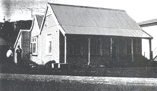
Though additions and alterations have been done to Tawa’s first school since it was completed in December 1859, these have done little to alter its appearance. The main changes which have taken place are the windows on the north side and replacement of the original shingle roof with corrugated iron.
The teacher’s residence was at the back. It was separated from the classroom by a thick partition which must have been there for reducing noise in the home. Inspector’s reports mention that the classroom was poorly lit. This would have been before the window on the north side was added.
The interior joinery and moldings indicate that the Provincial Council must have stipulated certain specifications in the use of materials.
In its early years the schoolroom had no heating and the hesitation of officialdom in spending any more money than necessary is evident, for several years passed before it received its first coat of paint.
[This text and photo were repeated in the Kapi-Mana issue of 26 October 1976, p 15, under the heading of “Borough's first school was completed 117 years ago”.]
The offer of Mr Bartlett in leasing a quarter-acre of his 100 acre farm for no financial reward was generous to say the least.
The emigration list of the New Zealand Company record Bartlett as being an agricultural labourer who arrived in 1842 with his wife and four of his six children. His social background and the times indicate he would have had little or no schooling himself.
Furthermore the 100 acre section which he had purchased at Tawa Flat was the reward for 17 years hard work along the Porirua Road during which time his family would have had little opportunity of receiving formal education.
Tenders were immediately called for the erection of a school house and attached master’s residence. The successful and lowest tender for the well preserved house which can be seen at 14 Oxford Street, Tawa, was the one submitted by J Morgan for £90.
The school with master’s residence attached was completed in December 1859 and ready for opening in January 1860.
Though the contractor’s price was £90, incidental expenditure for the purchase of books, furniture and provision for fencing raised the total to £102. The settlers contribution towards the cost was £50.7.0, leaving £51.13.0 to be met by the Provincial Government.
These figures were later amended for in the financial report of May 1860 the council’s half share was £116.6.0 this figure included £65.19.0 being half of the teacher’s salary.
Tawa Flat’s first school is in sound structural condition today, though little of the original pit sawn weather board remains. Apart from extra windows being fitted the house is much the same as when first opened.
Being invited inside by Mrs Philips, one is amazed how her comfortable lounge was once a dimly lit classroom, where within its 168 square feet were fitted three desks to seat a roll which in 1866 had increased to 44 pupils. One point that comes out in the inspector’s reports of the 1860’s was that attendance was irregular.
The erratic attendance was not so much a question of truancy but stemmed from the attitude of society towards children at that time. Before the days of child labour laws even the fondest of working class parents looked on children as a means of helping in the home and supplementing the family income.
Elsdon Best who was born at Grasslees, site of the Tawa Exchange, in June 1856, records these times in “The Bush Settlers of the Wellington District” when he stated most of the old bush farmers were unable to spend much money on the education of their children for they were ever in the stern grip of poverty.
Best also recorded interesting information about Tawa Flat School when he was a pupil. Schools were by no means high class academics. The small school at Tawa Flat being a fair example of a country school. They were primitive and the pupils learned to read and write without gaining a great deal of scholastic lore.
Mrs Frances Greer (nee Pilcher) who was born in 1848 and settled with her family at Tawa Flat in 1851 gave Arthur H Carman an interesting insight into country education in her childhood. Mrs Greer’s reminiscences are interesting because her schooling was at two of Best’s by no means high class academics.
Her first school was in a private home at the rear of the old Wesleyan Chapel. This school which served the district’s needs up to 1859, was close to the boundary of the present Tawa primary school. In her conversation with Mr Carmen she stated “her schooling was very little and she could only attend when convenient.” To make matters worse the hours of this private school were in the evening.
Not only boys had to forsake schooling on order the help the family for girls had to milk cows, work in the dairy and attend to pigs. Under these circumstances when it was time to attend night school education would go by the board.
Best’s mention of the poverty of some early settlers throws new light on inspector’s reports. The report of April 1867 has these pertinent remarks.
Mixed school, mostly little girls under mistress Mrs SM Tauton, with female monitor, building very small, no fire place, room badly arranged, books and apparatus very deficient, no blackboard or small maps, teacher Tauton recently resigned.
Financing Tawa Flat School remained a problem. Cause of concern to the early school committee was the dangerous unfenced Keneperu stream which then flowed through the school grounds. When inspecting the old playground this dangerous bank could be seen in the adjacent property. Flooding was also a problem.
Before the bush cover was removed from the surrounding hills the streams in the Wellington area carried a greater volume of water than they do now. JC Crawford’s description of the Kaiwharawhara and early paintings and sketches give proof of this. Though flash flooding though rapid run off was not evident, after heavy rain they took longer to go down.
In 1878 the authorities were forced to construct a new residence for the teacher as the district population required the whole building to be utilised as a school.
This was only a temporary measure for on May 29 1879 the Education Board accepted a tender from Mr W Taylor for the erection of a new school.
Colonial Cottage – a fine memorial
By W H Secker
This is the second of a series of articles written for the Historic Places sub-committee of the Tawa Borough Council in which information on landmarks within the borough will be recorded. This article was first published in the local community newspaper Kapi-Mana News on 18 November 1975, pp11-12.
The well preserved colonial cottage on the east side of the main road at Linden halfway between St Aidan’s Church and McLennan Street has been a prominent landmark since pioneering sawyers and small farmers moved into the district in the early 1850’s.
When Andrew Brown erected the cottage of simple design it was not necessary to deposit plans and specifications in order to build, so it is not possible to pinpoint its age accurately.
Members of the family believe it was built 1854-55, although the simple design of the original structure suggests this could be advanced a few years to when the first pioneers settled at Tawa Flat.
Andrew Brown was middle-aged when he decided to emigrate to New Zealand with his wife Mary and adult son and daughter.
Whatever reason prompted the Scottish woollen mill worker from Paisley to migrate to New Zealand remains a matter for speculation.
Looking back after 125 years it would seem reasonable to assume he was a crofter who had been caught in the flood stream which dragged rural workers into the towns of industrial revolution Britain.

THE HILLS surrounding still carry the signs of when pioneer sawyers like Andrew and James Brown were engaged in the heavy work of cutting timber.
After more than a century of trampling by stock, weathering and the natural build-up of soil through biological causes, few sawpits are as bold in their relief as this sample on Mr G Warren’s property at Glenside.
New Zealand’s broadleaf podocarp forests, of which a remnant can be seen immediately behind the pit, were not production forests like pine plantations.
This is due to the cuttable timber being scattered. This made it necessary for old-time sawyers to construct pits where ever it was an economical proposition.
People like the Browns felled totara, matai, miro, kahikatea and rimu which would be hauled into position by block and tackle.
In early colonial times horses were expensive and even if funds were available there were often none for sale. They also required feeding which was another hurdle.

Brown's Cottage 1938 - photo Carman
Section 49, Porirua District, on which Andrew Brown built his home was first owned by an absentee landowner, Sir Boucher Palk, Bart., of Barnstaple, Devon. Sir Boucher was one of many shareholders in the New Zealand Company who invested solely for monetary gain.
Under the rules of the New Zealand Company all shareholder who invested the minimum requirement of £101 were entitled to one town acre and a further 100 acres (more or less) in the country.
When the baronet speculated in a piece of New Zealand real estate the company’s agents had not been able to advise the London office of the exact location of the land which had been purchased from the Maori owners.
Though this lack of information would have given rise to concern, the absentees realised that wherever their section happened to be it could not fail to appreciate in value due to the exertions of the working settlers who emigrated to New Zealand.
Not being resident in New Zealand the baronet was obliged to leave the choice of this section in the care of the company’s agents. After the property had been registered in his name, a report would be sent describing its potential in glowing terms.
Unfortunately the distance of Section 49 from Wellington and the capital outlay required in bringing it into production would be glossed over.
Andrew Brown would probably have arranged to buy the section before leaving Scotland. The price asked by the owner would have been far in excess of the £101 he paid for it as it had appreciated in value through the colonists efforts in developing the wilderness.
Before the Land Claims Commission could get around to investigating the claim before registering the Crown grant, transfers of this nature could be undertaken without incurring legal expenses. All that was required was the signature of both parties to the transaction being witnessed by a respectable person.
Andrew and Mary Brown arrived in Wellington by the Marriner on September 2, 1850. Soon after landing, the family moved to Section 49, Porirua District.
The sight that met their eyes would have been a traumatic experience for, instead of common land reminiscent of England, they were confronted with forest which had to be cleared before farming could proceed. Some idea of the strain placed on the family’s limited financial resources can be gained from the information that James, the son, had to wait five years before he was in a position to advise his Scottish fiancée, Janet MacVicar, to join him on the Porirua Road.

WHEN Andrew Brown built his cottage in the 1850s the Porirua Road ran at what is now the rear of the house. Before extensions were added in the 1880s the house consisted of a kitchen-living room and bedroom on the ground floor.
Upstairs in the attic was another bedroom making 800 sq. ft. of living space. The fire place in the attractively furnished lounge is a reminder of when cooking and baking bread for the household was done in the camp oven.
At one time a swae which would have allowed pots to be slung across the fire at different heights, would have been fitted into the bricks.
After the Murchison earthquake the chimney was weakened and had to be rebuilt. The original bricks which would have been made in the district, were cleaned of lime mortar and reused so the chimney and fireplace remained unchanged.
In a wooden house which is now over 120 years old other maintenance has been done over the years. Some of the weatherboard has been replaced, but this has been done so well that it needs a trained eye to detect the renovations.
The cover board gives an indication of the original size of this historic Linden landmark which was built when sawing was the district’s main occupation.
The Wellington Provincial Electoral roll, for the Wellington Country Districts for the years 1865-55 includes the name of Andrew Brown as being a farmer of Mavis Bank, Porirua Road. His qualification for being able to exercise the franchise was that of householder whose property was valued more than £50.
Though the name Mavis Bank could have had some nostalgic connection with Scotland it was also an apt and descriptive title for his pioneer bush farm. Immediately behind the alluvial flats bordering the Porirua Road rose a steep 150 ft bank of which a portion behind the cottage was planted as a garden at an early stage.
Family history records that when Andrew and Mary Brown emigrated, they shipped among their personal possessions some plants growing in glass jars so they would not make a complete severance with their home homeland.
Now, 125 years later, one of the young holly trees brought out in a Victorian terrarium still survives in flourishing condition. Equally significant is a double form of the sweet briar Rosa Eglanteria ‘Mannings Blush’ which still survives on the road reserve.
This old shrub rose, known to be in existence before 1799, is not as aggressive as its parent. Originally this rose was planted as a hedge and would have made a delightful sight when its blush-pink buds appeared in the early summer. It is of horticultural interest as there appears to be no record of it growing anywhere else in Australia or New Zealand.

Mavis Bank – still a country garden
THROUGH suburbia has encircled Andrew Brown’s cottage it still retains the atmosphere of when it was a farmhouse. The neat and spacious garden with its farm shelter belts, fruit trees and well maintained cowbale which serves as outbuildings all lend to what could be described by a town planner as a place of scenic beauty. .
Among the interesting features in the garden is what must be the oldest drain in the borough. The ditch, which still carries running water, is a reminder of the hard work some landowners had to drain the then swampy valley floor. .
The tree at the edge of the drive is the sole survivor of a number of young plants brought to New Zealand by Andrew and Mary Brown in 1850. .
When the family first settled at Tawa Flat they would have had few neighbours and for Mary Brown life would have been lonely. .
Life was hard for womenfolk as water for cooking has to be carried in from an outside well. .
The lack of a water supply made it necessary to wash and do the laundry outside. .
In the 1850s the lack of water in the home was not uncommon and even the well-to-do seldom had a bath tub installed in the house.
S.C. Brees in “Guide and Description of the Panorama of New Zealand” (published 1849) writes of the sawyers as if they were a bunch of rough necks, a race apart from the rest of colonial society.
This stereotyping of an occupational group was not strictly accurate for many aspiring farmers, like Andrew and James Brown, through necessity were forced to undertake this work in order to clear their holdings.
Because of their Scottish background the Browns would have been somewhat dour folk. This natural characteristic did not prevent Andrew Brown from being elected to committees.
One organisation he served was the patriotic committee formed by settlers of the Porirua Road District to help dependants of soldiers killed in the Crimean War.
At the inaugural meeting patriotism was so aroused by impromptu speeches that a collection was made on the spot. Settlers who came across with a donation to start the fund were all relatively prosperous.
Pioneers like Andrew Brown did not appear in the list of donors because they did not have enough spare cash for this charitable work. Their ideas of helping destitute dependants of servicemen were in the form of offering goods and services.
Though the family’s financial affairs were stretched, the Brown’s were generous and when swaggers roamed the countryside they were known never to turn these colourful characters away without giving them some assistance.
Today no street name records of this pioneer family which still has a connection with the district. It is unlikely that the oversight could be rectified because of confusion with street names in neighbouring cities.
The old colonial cottage however, is a fine memorial.
Bartlett house reflects changes
By W H Secker
This is the third of a series of articles written for the Historic Places sub-committee of the Tawa Borough Council in which information on landmarks within the borough will be recorded. This article was first published in the local community newspaper Kapi-Mana News of 9 December 1975, p16.
The old style colonial farm house at 26 Oxford St, Tawa, not only records how the style of home architecture improved in the 1860s but serves as a reminder of the caliber of some of the working class settlers who emigrated to New Zealand in the 1840s.
In early colonial times not all the small settlers who were ambitious and industrious enough to purchase land found that they had committed themselves to a financial burden. Some of the pioneer settlers like Nathaniel Bartlett were able to improve their circumstances through their farming ability and a sound head for business.
The life and times of Nathaniel Bartlett proved an interesting study for the social historian as a case of how a pioneer of lowly status was able to improve his lot through his willingness to settle out of town and not claim poor relief from the New Zealand Company.
The embarkation registers of the New Zealand Company show that Nathaniel Bartlett his wife Sarah and four of their six children, arrived at Wellington onboard the barque Clifton of 820 tons, in February 1842.
At the time Bartlett arrived at Wellington the infant town and surrounding districts were enjoying prosperous times through the amount of money put into circulation from the sale of land. These times were short lived for within a year New Zealand was to experience the worst depression in its history.
So bad were those times that business firms and small traders refused to accept as legal tender the paper money issued by the Government of the day.
The cause of this depression which resulted in great hardships to the labouring classes was the curtailment placed by the Government on the sale of Maori land till such time as the Land Commissioners had investigated the deeds of sale.

Since the Bartlett house was built in 1862 there have been several additions to the original dwelling. These have in no way detracted from the appeal of the original structure which is the portion with the attic bedroom.
The single storey was added by someone who desired to live in the country.
The quiet charm of this colonial style residence blends in with houses which have been erected at various stages so that this part of Oxford Street is one of the most pleasant parts of the Tawa borough.
When Nathanial Bartlett built this residence, Oxford Street was part of the Porirua Road.
In many ways the Bartlett house reflects the evolution of Tawa form a pioneering district to a desirable residential area of greater Wellington.
By today’s standards the original part of the house loses nothing in comparison with modern dwellings because it was of good design when first built.
This action prevented settlers with money from engaging labour to construct shops, houses and develop sections out in the country.
Another contributing factor to the depression was the meager budget voted by the House of Commons in London for meeting the administration expenses of the infant colony.
The economy of early Wellington did not pick up until the Maori rebellions at the Hutt and subsequent military operations resulted in money being put into circulation through military spending.
It is not known what privations the Bartlett family endured during these times but form all accounts their circumstances were better than other members of what we call the labouring classes.
The appearance of the name of Nathanial Bartlett on the 1844 jury roll as being a resident of the Porirua Road indicates that at this early date he must have leased some land with the eventual right to obtain the freehold.
Some idea of how Bartlett had prospered in his adopted country can be gauged by the 1848 census which had been compiled by the New Zealand Government to show how some of the emigrants had improved their social status since their arrival in the Wellington settlement.
This unpublished census contains some interesting data about small land owners along the Porirua Road.
Bartlett’s name is recorded as being an emigrant who since his arrival in the colony had improved his status by graduating “from being an agricultural labourer to that of a labourer and owner of land.”
Further statistical information records that he had cleared two acres of forest for grazing, with a further two acres under crops while his livestock consisted of three cattle, a goat and a pig.
The non mention of a horse among his livestock would have meant he would have been handicapped by having to work close to home.
The absence of sheep among the livestock figures of Bartlett and other small land-owners in the 1848 census returns has nothing to do with the widely held belief that there was no feed for these animals on pioneer bush farms in the Wellington area.
The truth of the matter was that this was against Edward Gibbon Wakefield’s principles of colonisation.
Wakefield’s prejudice against small land-owners keeping a flock of sheep arose from his belief that it would supplement the labouring classes’ incomes so that their usefulness to the work force would be reduced.
The land Nathaniel Bartlett was farming in 1848 was situated between Cockayne and Crofton Roads, Ngaio.
The lessons he learned in farming and doing contracting work in this area were later to be put to good use when he developed his 106 acre farm at Tawa Flat in the mid 1850s.
It is not known with certainty when the Bartletts moved to Tawa Flat and began farming on Section 44, Porirua District. The evidence points to the year 1855 when Nathaniel Bartlett shifted from Crofton to Section 44 which at that time was owned by an absentee land owner, the Reverend Jonathan Cape of Croydon, England.
When Bartlett shifted to Tawa Flat, it is not known what state section 44 was in. Some absentee landowners have permission for agents to arrange for salable timber to be removed on payment of a royalty. If millable timber had been extracted it would have made the conversion to farmland so much easier for the new owner. In pioneering days it was not uncommon for squatters to occupy land held by absentee owners and newspapers of the times often carried in their public notice columns threats of legal action for trespass and removal of timber form empty sections.
One point that comes to mind over Bartlett’s shift to Tawa Flat is that some form of development of Section 44 had taken place. There must have been a house already on the section for the old Bartlett home which survives the years at 26 Oxford St was not built till the early 1860s.
The house which members of the Bartlett family lived in when they first shifted to Tawa would have been what the early settlers called a wattle and daub cottage. This was a dwelling where mud reinforced with raupo or Rie Rie leaves was plastered over a framework of saplings cut from the bush. Those of sounder construction possessed a wooden floor.
By the time Bartlett settled at Tawa Flat, burning off bush was down to a fine art. Bartlett himself would have had plenty of experience in this work while resident at Crofton.
The object in burning off was to create a hot fire which would reduce to a white ash all vegetation. A fierce hot burn would also destroy seeds and fern spores which be lying dormant on the forest floor.
The secret of obtaining a fierce fire was after marketable timber had been removed, to cut down the undergrowth and allow it ample time to dry out. On slopes larger trees could be scarped on both sides so that when a tree on higher ground was felled it created a chain reaction by bringing down all objects in the direction of the fall.
By this method clearing the section was speeded up.
The favourite time for burning was in December and January on a day when the wind was favourable. Best results occurred when the fire was lit on as broad a front as possible.
On terrain like Section 44, Porirua District, however, it would not be possible because of gullies and damp areas to complete the burn in a single operation. This would mean that the farm’s development continued over a number of years.
Immediately after the burn grass seed would be sown. This operation was performed by broadcasting with two hands. At a casting length away and a few paces behind, others followed so that an even distribution was obtained.
In steeper faces of which there were one or two on the Bartlett farm, it would be necessary to hold onto tree stumps and use one hand for sowing.
Pasture suitable for sheep grazing would be established within three months. Turnips were occasionally sown with grass seed after the initial bush burn, so that extra feed for stock would be available in the winter.
In the 1860s Dronsfield, a Wellington merchant advertised a mixture of perennial rye grass, cocksfoot and white clover. Another seed mixture marketed by Suttons included cocksfoot, timothy and white clover.
At the time Bartlett was establishing his farm at Tawa, farmers were still learning through trial and error about the best seed mixtures for farming permanent pastures in different situation. The ratio of cattle beast to sheep in order to control the re-emergence of fern and scrub had also to be worked out by trial and error.

This advertisement inserted in the Land for Sale columns of the New Zealand Times appeared throughout January 1875.
It gives a fair and accurate description of what must have been one of the best run farms in the district.
The description of a four-roomed house was before the home was extended and interior alterations made.
Mention of a barn, cowshed and outbuildings with a good garden well stocked with fruit trees gives a picture of an English farm transplanted to the Antipodes.
The high number f sheep carried (400) looks as if the farm could have been an early example of specialised farming.
Though Joseph Bartlett (the then owner) did not realise it, his concentration on sheep and the omission of cattle for browsing off rough growth was encouraging the deterioration of the pasture comprising good English grass.
Ten years later the farm had deteriorated through the soil declining in its fertility and scrub appearing in the less fertile paddocks.
This made its profit marginal.
The advertisement failed to clinch a sale. Six months later it was sold after Joseph Bartlett had died under unfortunate circumstances.
The whole area has changed since the year the Bartletts farmed Section 44.
The construction of the Wellington and Manawatu Railway, the Tawa Flat deviation in the 1930s, and widening and straightening of the Kenepuru Stream have obliterated the orchard and outbuildings from the map.
The enactment of the Fencing Act by the Wellington Provincial Council in 1854 made it mandatory for all property owners to fence their sections.
This Act created employment for settlers like Bartlett. It also removed a source of friction between Maoris and settlers for since 1840 a certain class of European showed no concern over what harm wandering stock did to Maori cultivations.
As there is no sign of hawthorn or holly having been used for fencing on Section 44 the barriers erected to control stock would presumably have been the post-and-rail type of fence.
Because of the risk of slumping and sheet erosion, post-and-rail fences followed spurs and ridges. Viewing the Bartlett farm form the opposite side of the valley the layout of the paddocks can be worked out.
Nathanial Bartlett played a role in community affairs. This comes out in giving a part of his farm to the Wellington Provincial Council for education purposes, his seconding the nomination of the respected Wellington lawyer Alfred de Bathe Brandon to represent Porirua in the General Assembly, election to the ratepayer’s association and school committee which in Provincial Council days were bodies empowered to levy and collect rates.
Nathaniel Bartlett and his wife would have been casualties of Britain’s industrial revolution. The series of Enclosure Acts passed by the British Parliament made the small tenant farmer and agricultural worker who grazed his stock and raised crops on the British commons an anachronism in the new society.
People like the Bartletts could either emigrate or join the growing ranks of the urban and rural poor. Because of their simple lifestyle they were better fitted to adopt their ways to the hardships of colonial life than many a middle class settler was able to manage.
Tawa’s history is not tied to present boundary
By W H Secker
This is the fourth of a series of articles written for the Historic Places sub-committee of the Tawa Borough Council in which information on landmarks within the borough will be recorded. This article was first published in the local community newspaper Kapi-Mana News on 17 February 1976, p18.
In writing about historic sites around Tawa it is necessary at times to step outside the present borough boundary in order to show how the first pioneer families lived and how easy it is to remove traces connected with the early settlement period.
Though land owners are entitled to develop their properties as they see fit when their plans comply with the provisions of the Town and Country Planning Act and local ordinances there is always cause for regret when a vista associated with a district has to disappear in the path of progress.
At Glenside there is a good example of the clash of interests between development of land so that best use is made of a valuable asset and the preservation of aesthetic values.
The piece of land in question fronts Stebbings Road from its junction with Middleton Street (the original Porirua Road) and where it disappears from sight at the first bend.
This attractive sylvan setting with its hedgerows which creates an atmosphere of a Southern English county is destined to vanish in the not-too distant future as Churton Park and road widening destroy the peaceful atmosphere of Glenside.
The area under threat was originally surveyed as Section 22 Kinapora District.
The history of development of the 114 acre section, once covered in dense bush, goes back to the first years of European settlement. The hedgerows and some of the broad leaf trees which have survived were planted soon after the first settlers arrived in the district in 1841.

Memories of Thos Arnold at Glenside
In 1848 while waiting for part of his Tawa section to be cleared so that a dwelling could be erected, Thomas Arnold stayed with the Barrows at Glenside.
The site of the Barrow cottage can still be made out in front of the hedgerow in the foreground. Live fences such as this were commonplace before wire became the standard article for restraining stock.
The grassy patch at the bend in the road is approximately the site where Susan Wall ran her inn, The Surveyors Arms, in 1842.
Though the inn’s accommodation was rough and ready with some travellers having to spread themselves out in front of the fire wrapped in a blanket, it was far from being a grog shop and doss house.
Both the Barrow and Wall holdings were model small farms that were incapable of keeping a family above the breadline unless other employment was undertaken.
The early settlement period of Tawa followed a similar pattern.
Records show that the first owner of Section 22 was a J T Leader who decided to remain in Britain.
In April 1845 Leader transferred the title to Edward Jerningham Wakefield who had been resident in New Zealand since the spring of 1839. Edward Jerningham was a son of Edward Gibbon, the organising genius of the New Zealand Company and nephew of Colonel William Wakefield who was the local agent entrusted with looking after the organisation’s affairs in the newly founded colony.
Land transfer records reveal that after Wakefield lost interest in Section 22 it changed hands a few times before title was transferred to James Barrow and W Strafford as joint owners in February 1861.
James Barrow, his wife and family, arrived at Petone on the Aurora in January 1840. It is not known with certainty when the family settled at Halfway – as Glenside was known till some bureaucrat in the old Public Works Department decided in the early 1930s it was not a suitable name for the camp serving as headquarters for the men engaged on the Tawa Flat deviation of the main trunk railway.
It is reasonable to assume the Barrows were resident at Halfway at an early date and had erected a dwelling on Section 22 at the time E J Wakefield was its lawful owner.
The 1848 census records some useful information of Barrow’s circumstances. On a page which shows what small landowners of the labouring classes had achieved since their arrival in the colony, the name of J Barrow was listed as having cleared 15 acres of which 13 acres were under crops. His live stock consisted of five cattle and one sheep. This development took place while he was engaged to clear land for those able to pay the price.
Barrow was originally a Kentish agricultural labourer and the hedgerows which survive on Section 22 would have been planted by him or one of his sons.
In using hawthorn, holly and the odd sweet bay tree to divide his farm into small fields he wittingly created a replica of the Kentish countryside. The age of the trees indicates they could be 130 years old.
Charles Heaphy in his informative classic “Two Years’ residence in New Zealand” which covers the period between arrival of the Tory in the spring of 1839 to his temporary departure from the colony in December 1841 shows that in November of the latter year there was no lack of work at Halfway for energetic workers.
Monied people who employed labour or engaged contractors to fell and burn bush on their country sections were Frank Johnson Esquire, owner of Section 24, Major Hornbrook (Sec 15), a gentleman who like the Hay’s and Dean’s cut their ties with Wellington in 1843 to make easier living in Canterbury. T J Drake was another early settler who engaged help to clear Section 19 so that farming could start in earnest.
In pioneer days families improved their lot by working together to an extent which is not noticeable today.
On the neighbouring property (Section 24) Susan, wife of Anthony Wall, ran an inn to meet the needs of travellers between Wellington and Porirua and settlements to the north.
This enterprise supplemented the six shillings her husband earned for working an eight-hour day clearing and burning bush.
When it could be arranged, pioneer settlers like Wall and Barrow preferred to work on contract as they found it more remunerative.
Whether in 1842 the Walls had got around to applying for a bush licence to sell fermented and spirituous liquor remains a moot point.
By December 1842 they were well enough established to supplement their income even further by “having two cows and a calf, and enough dairy-fed pork to supply their requirements. Cabbages peas, potatoes and other vegetables were also ready in abundance.”
Following the general custom of the time a second crop of potatoes was planted in the wake of the harvested early crop.
In her letters Susan Wall mentions other settlers being in the district which was then a frontier society with Maori wasteland lying between Halfway and Porirua.
It was the refusal of the Ngati Toa to sell the wastelands which delayed settlement of Tawa Flat and the Takapu Valley.
The Barrows supplemented their income by taking in a boarder. From letters of Thomas Arnold who lived with then in 1848 while scouting around for a section we gain as insight into the nature of this pioneer family of humble status. Though of different social backgrounds Arnold and the Barrows got on well together to the mutual benefits of both parties. Arnold in a latter written in July 24, 1848 mentions “that I am living with a small farmer named Barrow from Kent. We live together in a most sociable and pleasant way with the old man and his wife and four children, one of whom is married (Mrs Jones), her husband and two children.”
Arnold was given a room to himself although he had his meals with the family. In return for their kindness Arnold gave lessons in the evenings in reading and arithmetic to the grandchildren.
Arnold also made a contract for Barrow to fell and burn five acres of bush which had to be cleared from Section 40 before he could erect a whare and move to Tawa Flat.
The construction of Arnold’s whare for which he tentatively selected the name of Fox How to remind him of his father’s home in Westmoreland was left to the Barrows.

The central built-up area on the flat between Tawa Terrace and AC Hatrick’s factory marks the approximate area (circled) Thomas Arnold cleared in 1848.
Found of nature he left the bush on the higher ground to form an attractive background for his whare which he called Fox How.
Arnold walked the distance from Glenside when he took a hand in helping to clear the section and supervise the erection of what to someone in England middle class background would have been a primitive though comfortable dwelling.
In 1848 apart from odd clearings the area back to Glenside was in bush.
On the flat the bush was lighter than the vegetation clothing the hills.
Fox How occupied the site where Aquaheat Industries Ltd had its office.
Simple Structure
It was a simple structure of two rooms. The walls were vertical slabs made weather proof by packing the crevices with mud (daub as it was called by the settlers). Weather board was laid on the rafters with totara shingles making the roof watertight.
Construction of the chimney proved the biggest obstacle as the stones in the Kenepuru stream were not suited for this use.
Though Arnold was not cut out for roughing it in a frontier society he took some part in clearing his section which can be identified as being the stretch between Hatrick’s factory and Tawa Terrace.
To get to his section he walked from halfway, returning home in the evening, at 6pm. His estimate of 3 ½ miles from Barrow’s place to Section 40 was excessive even after allowance is made for the windings and gradient of the Old Porirua Road with its numerous fords. If he was estimating the distance of the round trip he was on the light side.
Nelson
Arnold did not live long at Tawa Flat. Toward the end of 1848 he accepted a teaching position at Nelson. Misfortune at this time struck him for though some legal wrangles he had to forfeit all claims to the property.
Apart from the time and money he had spent in developing his holding so it would meet most of his needs, he had become enraptured by the peace and quietness of Tawa Flat. The section was also more valuable than neighbouring properties through less steep.
It says much for Arnold’s strength of character that he never carried a chip on his shoulder. His sojourn at Halfway and pioneering activities at Tawa are covered in his autobiography “Passages in a wandering Life.” From a parochial point of view Arnold’s greatest claim to fame was when he received a visit from the Governor, then Captain George Grey.
At the time Arnold was dressed like a navvy as he was working on his section. The visit was to ask Arnold to accept the headmastership of the Episcopal college to be established at Porirua. The position was declined.
Boscobel Farm tells an interesting story
By W H Secker
This is the fifth of a series of articles written for the Historic Places sub-committee of the Tawa Borough Council in which information on landmarks within the borough is being recorded. This article was first published in the local community newspaper Kapi-Mana News on 13 April 1976, p32.
Though it became necessary in the mid - 1960s to demolish Boscobel, the attractive double story home which had been built for William Earp over 100 years before, there are still enough reminders of the district’s past to make what is left of the farm the most interesting part of old Tawa.
William Earp who gave this Worcestershire place-name to Section 37, Porirua District, arrived at Wellington on December 23, 1854 with his wife and three children, all of whom were under eight years of age.
Soon after their arrival in the colony the family moved to Tawa Flat. The land transfer records reveal that on July 18, 1855, George Frederick Young, a director of the New Zealand Company transferred Section 37 to William Earp and Charles John Harrison as tenants in common.
This transfer turned out to be only a temporary arrangement for on November 18 [1857], except for one acre on which he had a dwelling, the remainder of the section was transferred by Harrison to Earp.
The outbuildings of Boscobel were designed to be in harmony with the house. The workmanship which went into the building can be appreciated by the ornate fascia board on the left gable.
The weatherboards are original pit sawn timber which makes the structure 115 years old.
Immediately to the right can be seen one of the live holly fences which would have been planted soon after William Earp and his partner John Harrison settled on Section 37, Porirua Road District, in 1855.
The holly hedges are now up to 30 feet (10 metres) in height and sub-divide what remains of the old farm into small paddocks.
Overall, the impression is that of an English farm which was efficiently run by a yeoman farmer.
At this stage the Earp family was not living in the old Tawa landmark, Boscobel, as family history records that this attractive pioneer home was not built till 1860.
In the first years of pioneering at Tawa Flat, William Earp would have been the local counterpart of what settlers like F Johnson, Major Hornbrook and T J Drake were to the Johnsonville and Halfway districts when farms had to be created out of the primeval forest.
Unlike the majority of Tawa Flat’s pioneers the Earps had the advantage of belonging to the middle class.
Their capital resources enabled them to live in reasonable comfort over the initial settling in period and, because they were in a position to hire labour, the farm soon became an economical proposition.

The inverted bucket-shaped macrocarpa has been listed as one of the historic and notable trees in the southern North Island.
Its claim to fame is that it is an early planting of cupressus macrocarpa and has been a notable landmark on the road to Wellington as long as anyone cares to remember.
As a specimen tree it is one of the few examples of the ancient art of topiary in the country.
The tree fits well with the old world garden and the modern dwelling which has replaced William Earl’s Boscobel.
An examination of the tree confirms the belief of older residents that more than one plant has gone into its shaping.
From ground level it looks as if six plants could have been planted close together.
Over the years these individual plants have coalesced to form what botanists call a natural graft.
Because of its historic association with the Wellington area, trimming the tree is undertaken by the Tawa Borough Council.
Obtaining title to Section 37 must have given Earp great satisfaction for apart from some infertile slopes the property with its fertile alluvial flats which faced towards the northwards ideally suited for a number of agricultural activities.
Remnants of the higher productive alluvial flats and features of his pioneer farm where sheep farming, dairying and fruit growing were all engaged in from the earliest years can be seen by rail passengers at Takapu Road Station.
What the original state of Boscobel was like when Earp and Harrison pooled their resources to become tenants in common in 1855 is open to speculation.
From documentary evidence it can be deduced that some removal of bush had already taken place.
For one thing it is known that in 1840 Maori cultivation grounds were sited at the confluence of the Kenepuru and Takapu streams.
As their system of agriculture exhausted the soil new clearings would have to be made over the years so that the present and former cultivations could have covered a wide area of open country.
McCoy’s stockade was also located in this vicinity when the British troops were engaged on constructing the Porirua Road in 1846.
Further inroads would have been made at this time to obtain timber for the command post and construction purposes.
The area around the stockade would also be cleared to give a view of the fords and avoid the risk of sudden attack from the enemy.
Looking back into the past it can be seen that the two partners who emigrated to New Zealand on the same ship, the Pudsey Dawson, were soon at logger-heads as to which way the development of the farm should take.
Earp’s idea was to develop a small mixed farm in which, sheep, dairying, poultry and fruit growing would all be practised.
Harrison who after leaving Tawa Flat in 1860 to settle on a 2,300 acre estate near Marton would have had other ideas.
Personalities and the lives they lived in England would have been another cause for strain.
As events turned out, Earp was given full scope to develop Section 37 along the lines of an English yeoman farmer’s property before the industrial revolution changed the face of the countryside.
Further evidence to show how the two friends drifted apart can be seen from the report of a court case in which Harrison sued Earp for setting fire to his property.
This case was a bitter affair and occupied the court most of the day before the magistrate Mr St. Hill, found for the plaintiff and fined Earp the sum of £10.

This public notice which appeared in the New Zealand Times a century ago shows how William Earp had extended his farming activities since his arrival in the colony 20 years before.
Section 39 on his northern boundary was purchased in 1858 and on December 29, 1866, he bought Section 35 which his partner Harrison had retained after their arrangement was dissolved.
Section 60 was purchased in November 1874 and sold to the Crown as part of the proposed mental hospital site in February 1884.
Apart from aiding Boscobel’s finances, Section 18 and 19, Horokiwi Road District, are out of scope of this record of Tawa’s early history.
The briefly worded trespass notice would have given Earp the authority to bring trespassers to court under three separate acts.
These were the Larcency Act 1867, the Police Offenders Act and the Animals Protection Act.
The Larcency Act covered “the stealing of trees and shrubs that were used for fencing, the stealing of and live or dead fence, wooden fence, stile or gate and finding the person in possession of wood to which no satisfactory explanation was given, together with stealing of any fruit or vegetable production in a garden etc.”
The Police Offences Act gave the landowner the right to take a person to court for “willfully setting on fire any timber, bush, scrub, grass, fern, or flax.”
The notice also coincided with the approach of the shooting season. Apart from the damage and interference that shooting parties would cause to his farming activities, Earp because of his social background no doubt believed in the principle that native game belong to the landowner.
The Tawa Flat district was fortunate to have settlers of the standing of William Earp and Charles J Harrison in the pioneering days.
Both men took an interest in political affairs and in improving the cultural life of the settlers and small farmers living along the Porirua Road.
In the 1855-56 electoral roll for the General Assembly they were listed as being settlers. This was a social grade or two above small farmers who had mainly raised their status from that of labourers and mechanics.
Their education, general deportment and organising abilities made them logical people to serve on bodies which were impowered to levy rates for communal works.
Both Earp and Harrison served as wardens on the Porirua Road Board in 1856. Earp also served on the Tawa Flat school committee although none of his children received their education at the local school.
Harrison was also keen to form a Wellington Farmers Club which was to be modeled on the lines of the British Royal Agricultural Society.
Harrison spoke to the inaugural meeting held at the Halfway House on March 11, 1857 about the aims and objectives of the proposed society.
(to be concluded)
Earp orchard – a treasury
By W H Secker
This is a sequel to the article on Boscobel Farm in Kapi-Mana News on April 13. This is the sixth of a series of articles written for the Historic Places sub-committee of the Tawa Borough Council in which information on landmarks within the borough will be recorded. This article was first published in the local community newspaper Kapi-Mana News on 25 March 1976, p21.
Considering the pressures that an ever-increasing urban population had brought to bear on the earliest settled parts of the Wellington area it is fortunate that so many features which recall the time when Boscobel was a small mixed pioneer farm still survived for a later generation to appreciate.
Boscobel still retains an atmosphere of a bygone age with its small paddocks fenced with holly and hawthorn, old farm buildings of a design which kept them in harmony with the now demolished homestead and an orchard which supplied more fruit than the farm could consume.
The Wellington area because of the windy climate can hardly be regarded as a suitable district for a commercial orchardist.
Boscobel provided an exception because the topography and live shelter in the form of holly and hawthorn hedges made commercial fruit growing a practical proposition at Tawa Flat.

Boscobel Holly Hedge remnant today (2005)
The Earp orchard is of horticultural interest as it is a treasury of fruit trees which were in vogue over a century ago.
Considering the time that has passed since it was first planted it is not surprising that age, disease and insect pests have thinned out the rows.
Because of the inroads made by disease no plums or peaches have survived so that only representative of the stone fruits is a barren cherry tree.
Fire blight which would have spread from the neighbouring hawthorn hedges in the early 1920s has decimated the pears so that today only a few resistant trees survived. Of the pears a solitary tree of the variety Conference still bears fruit.
The bulk of the surviving trees consist of apples of a number of varieties and types. Considering the great age of the orchard and the hundreds of varieties of apples introduced or raised in New Zealand from earliest times it is not possible to name any of the existing varieties with certainty.

The Boscobel Orchard remnant today (2005)

This view of the remnants of William Earp’s orchard was taken in the spring of 1975 when the trees were in bloom
In its heyday the mixed orchard of different varieties of apples, pears and stone fruits would have made a useful contribution to Boscobel’s finances.
Though the trees are well past their best and have been neglected for many years, the orchard is still a pleasant spot. The topography and live shelter from hedges of holly and hawthorn provides good protection for the trees.
The orchard also possesses natural beauty for the lie of the land toward the northwest gives the impression that the valley is more extensive than is the case.
To someone of William Warp’s background from the pleasant part of rural England the family had emigrated from, the choice of Boscobel could have caused few regrets.
Within the orchard there is an atmosphere that time has stood still. The aura of over a century ago is enhanced by the slow flowing Kenepuru stream on the eastern boundary and the tall hedges which shut off suburbia from view.
Farm gates and small paddocks fenced off by 30ft holly hedges take a visit back to when the first generation of Earps farmed this interesting colonial farm modeled on the English pattern of a yeoman’s holding.
When the orchard was laid out, grazing stock between the trees was standard practice. By the way the trees have been trained and shaped, grazing was restricted to sheep.
However by using the Royal Horticultural Society’s method of classifying apples into different groups according to their colour, flavour and shape, a picture emerges of the type of apples in popular demand over a century ago.
All told, 11 varieties were present when a survey was taken in the autumn of 1976. These varieties for convenience sake could be placed in six of the seven categories which form the basis of the Royal Horticultural Society’s classification system of one of man’s oldest fruits.
These apples with the number of varieties in each group are :
• Lord Derby Group : Earp’s orchard represented by three varieties of large smooth skinned cooking apples which can be slightly flushed, but have no stripes.
• Lanes Prince Albert group : These smooth skinned distinctly stripped cooking apples are represented by two varieties.
• Peasgood nonsuch group : The most attractive apple in the orchard is in this group. Apples in the group are noted for their sweet eating qualities and smooth distinctly stripped skins.
• Golden Noble group : No representatives were noted in this attractive class to which the golden delicious belongs.
• Baumann’s Red Reinette group : This non-russetted group where the apple is almost covered with a dark brownish-red flush and with only the faintest of stripes being discernible represented by one variety.
• Cox’s Orange Pippin group : It is in this group that most of our dessert apples belong. Three varieties belonged to the group which is noted for its red coloured and russetted apples of good moderately good eating qualities.
• The Russet group : Two varieties belonged to this group which is noted for their complete absence of any red flush of stripping.
For their great age and neglect these trees were all carrying heavy crops and in the orchard’s heyday it would have been a profitable part of Boscobel’s finances.
One fault with the orchard’s planning was that the trees were planted too close together and not enough allowance was made for individual growth habits.
Tall pears, for example shaded lower growing apples, while the apples with a spreading pattern jostled for light with upright varieties.
The jobbing gardener who planted the orchard allowed 15ft between each tree in the row with a similar spacing between the rows.
This policy would have been right if thinning out of overgrown specimens had taken place over the years.
A solitary walnut which was barren completed the inventory of this interesting orchard which apart from the inroads made by age and disease is practically the same as it was a century ago.
The orchard tells a sorry story of the introduction of pests and diseases into New Zealand and the disappointments they must have caused to the man on the land before biological and chemical means could be implemented to control them.

In developing Boscobel, William Earp followed the farming practices he was familiar with in England.
The commodious home built in 1860, the spacious garden surrounding the home, attractive farm buildings, well laid out paddocks fenced with holly and hawthorn, together with an orchard speak of the family’s middle class background. Boscobel was demolished in 1965.
William Earp was one of the earliest sheep farmers in the district. In the 1861 sheep returns published in the Wellington Provincial Gazette, W. N. Luxford inspector of sheep shows Earp’s flock as 21.
Ten years later in 1871 his flock had increased to 600. The build-up in numbers by natural increase and further purchases gives an insight into the development of the farm in Tawa’s pioneering days.
In the early years of New Zealand’s sheep industry, stock was imported from Australia. Not all of these sheep imports were of high quality for in Australia’s earliest years some rough stock had been imported from the Cape and India.
The more discerning farmer would avoid this scrag mutton when bidding at auctions.
Farmers like Earp would have selected one of the dependable English breeds like the Lincoln, Leicester and Southdown. This was a time when improvements to the quality of the meat and wool was being undertaken by cross-breading with the established breeds.
Of the breads on this short list the Leicester played an important role in improving the fleeces of established breeds both in Britain and her far flung southern colonies.
The Lincoln also appealed to the early New Zealand sheep farmer and was in popular demand for cross breading purposes.
The original Lincoln produced a lot of fat which made it valuable for the manufacture of tallow. In Earp’s time this characteristic was not so pronounced as an animal producing good meat had been evolved.
The rather fine wool was up to 20 inches long (50 centimetres) and from the ewes a fleece of up to 14lb (6.5 kilograms) could result.
To the small landowner the Southdown was considered an excellent sheep. In the days before wire fencing this quiet and docile breed could be easily kept in bounds by the conventional fences of the time.
The Southdown would appeal to the early farmers of the district as it was hardy, adaptable and kept in good condition on a meager diet.
When given the benefit of foraging on first rate pastures similar to the awards established on the fertile areas of local farms it produced good quality mutton.
Dairying was another undertaking at Boscobel. Earp specialised in cheese making and it has been recorded that his preference for dairy workers were Danish immigrants.
Before the days of co-operative dairy factories the making of high quality cheese was skilled work that called for the upmost cleanliness and a rudimentary knowledge of bacteriology.
Resulting from the curdling of cream, it was all too easy to have moulds tainting the finished product. Heaving due to gas liberated by bacteria could also downgrade the value of the cheese.
Without any documentary evidence to go on, Earp’s cheeses would almost certainly have been one of the popular English lines namely Cheddar, Cheshire or Leicestershire.
His stated preference for Danish cheese makers suggests that the produce from Boscobel would have been Cheddar.
The process of making Cheddar would be known in Denmark, for this cheese which takes its name from a village in Somerset was even at this date regarded as one of the finest types of cheese ever created.

The marketing of farm produce 100 years ago differed from present day practice as these classified advertisements show.
The notice of a fruit auction consisting of 60 cases of apples and pears of different sorts could well be a consignment from a small orchard such as the Earp’s of Tawa Flat.
This was before orderly marketing of fruit was in operation and growers made a profit or loss according to the vagaries of the market.
There were also long periods when no fresh fruit was available.
Selling of the wool clip at this time followed the Australian pattern. In the produce section three merchants are in competition for the season’s wool clip.
The advertisement inserted by Edward Pearce is more for the benefit of squatters, who ran large flocks.
The advertisements run by the well known Wellington mercantile firms of Levin and Johnston and Co., would be of interest to farmers like William Earp.
New Zealand by this time has lost its isolation and was in contact by means of cables with the outside world. Wool brokers would therefore know market trends overseas to the advantage of both the grower and merchant.
In addition a firm like Levin and Co. would almost certainly have someone in its employ with Bradford experience so that good quality wool would fetch a reasonable price as no risk was involved in anticipating overseas demand for the local product.
The reference to advances meant that a produce merchant was willing to make an interim payment when a contract has been made with the farmer to consign produce to his store.
Following the Australian practice an advance could be in the form of supplying goods and services. In outlying areas where transport was virtually non existent the farmer often carted away merchandise from the store for an agreed amount.
The wool auction system was also operating at this time. However it differed form today’s set up in that a farmer’s clip was sold on its own.
Earlier in the 1874-5 season auctioneer R J Duncan advertised the pending auction of 20 bales of wool and a bundle of sheep skins at 12 noon on November 19, 1874.
Twenty years were to pass before the freezing of meat revolutionised farming in New Zealand. This was still the day of the small fellmonger who boiled down carcasses to make tallow, undertook scouring wool and paid cash for wool, hides and sheep skins.
Merchants also advertised for dairy produce in the days before co-operative dairy companies altered the manufacturing and marketing processes. James O’Shea, a Wellington merchant, was a “purchaser of prime butter” at this time.
Before co-operative dairy companies hundreds of small farms would be engaged in making butter and cheese. Quality would vary and a point that merchants would look for would be tainting through unclean dairy practices.
Packaging would differ with all sorts of containers being used for cheese. Butter would also be wrapped in different ways.
From what we know of Earp’s interest in cheese making the produce from Boscobel would have been of a high standard.
Early land sales at Tawa met demand
By W H Secker
This is the seventh of a series of articles written for the Historic Places sub-committee of the Tawa Borough Council in which information on landmarks within the borough will be recorded. This article was first published in the local community newspaper Kapi-Mana News on 27 July 1976, p19.
The shortage of land suitable for mixed farming in Wellington’s pioneering days was lessoned to a certain extent by the owners of the 100 acre country sections subdividing their holdings.
Though organised settlement of the stretch of the Porirua Road which was to become known as Tawa Flat did not take place till almost a decade had passed since the founding of Wellington, early land records show that the first subdivisions occurred as soon as the owners obtained title to their sections.
These early subdivisions along the Porirua Road at Tawa Flat followed the precedents already set at Karori, Wade’s Town, Upper Kaiwharawhara (Crofton), Johnson’s landing, the Halfway and settlements at the Hutt in the formative years of the Wellington settlement.
There was a difference at Tawa Flat, however, as in this district, owners had to endure a lengthy wait until the Land Claims Commissioners could get around to investigating the question whether the New Zealand Company had in fact made a bona fide purchase from the Ngatitoa.
Annoying as the wait was for the colonists who wished to get settled on land, the time taken by officialdom to grant title was necessary because of complicating factors.
The Land Claims Commission moved around the country investigating sales by native tribes to Europeans. The area to become known as Tawa was well down the list.
Investigation was also complicated as the Ngatitoa disputed having sold this area of the Porirua Road District to the New Zealand Company. Claims of earlier purchases by Sydney land sharks were also on the agenda.
Contrary to what one might expect, the first subdivisions at Tawa Flat were not made with the intention of capitalising on land which had increased in value since it was purchased by shareholders in the New Zealand Company a decade or more earlier.
The first recorded instance of a proposed subdivision at Tawa Flat comes from the pen of Thomas Arnold. This was when he wrote to his sister Frances in England on Saturday, August 12, 1848 “that in the course of a year or two there would be five or six families settled on his section.”
Arnold based his figures on the number of approaches that aspiring land-owners had made to him while in the process of developing his section.
When Arnold wrote of five or six families farming strips consisting no more than 20 acres, it was not with a view of increasing his meager capital.
Arnold was an academic and a dreamer whose education and upbringing had taught him nothing of farming, so that to overcome his handicap it was his intention to have neighbours so he could avail himself of their knowledge and services.
It was for this reason that in the winter of 1848, he decided to follow the advice of a fellow colonist in Otago and cotton onto someone who knew about farming and country life.
He put this advice to good use by lodging with the Kentish peasant Barrow and his family at Halfway on the Porirua Road while waiting for his whare Fox Flow to be constructed at Tawa Flat.
As things turned out, Arnold was unable to go ahead with his plan to subdivide Section 40, the piece of land situated between Rheem’s factory and Tawa Street long the Main Road.
This was because an uncle in England would not agree to Arnold being given power of attorney so that, as the man on the spot, he could best administer the assets of his father’s estate in New Zealand.
Consequently through the preliminary steps had been taken in acquiring ownership of Section 40 becoming null and void, there was no other option than to farm a steep piece of low fertility hill country just south of Makara Town Cemetery, if the land and not teaching was to be his chosen vocation.
In one of his letters Arnold records his disappointment with having to sever his links with Tawa Flat after making a diligent search to find a suitable section, cutting a boundary line, clearing a portion of it so that he could erect his whare Fox Flow as well as being able to grow vegetables and graze the house cow James Barrow had purchased for him while residing with the family at Halfway.
The person to gain the most from Arnold’s disappointment was Joseph Angell to whom part of the section had already been leased with eventual right of purchase as part of the arrangement.
However, though Arnold was to play no further part in developing Section 40, the plan he had envisaged went ahead with certain modifications.
The number of lots was reduced from six to three but Arnold’s somewhat radical plan of having a cross-section of community on the holding came to fruition with a gentleman, sawyer and small farmer taking up occupancy.
After the subdivision went ahead in the early summer of 1848 Angell, who was to become Tawa Flat’s first postmaster, acquired the northern strip of 58 acres.
John Wilmshurst, the sawyer, took the centre strip of 29 acres while his brother-in-law, George Mexted, a small farmer and contractor, purchased the southern lot of 29 acres.
The area of the three lots totals 116 acres. This is more than a generous baker’s dozen. The difference of 16 acres gives an indication of the difficulties the company’s surveyors encountered when marking out the hilly and forested terrain around Wellington into neat 100 acre parallelograms.
The Wellington area did not have these rough ands ready surveys on its own for it was common in new colonies where the work had to be done under great difficulties.
Nevertheless though this was a fact of colonial life it could result in legal arguments when a section was not the full measure.
To protect themselves, vendors often inserted the words “more or less”, when placing an advertisement in the “Land for Sale” columns of local newspapers.

Though the Hon. Algernon Grey Tollemache did not settle at Tawa Flat he played an important role in the founding of the district.
In August 1848 he was responsible for the first subdivision in the district when he placed Section 40, Porirua Road District on the market for sale in three lots.
His interest in property was not solely for gain for he enabled many a labourer to get settled on the land by arranging easy terms of purchases.
It is a pity no street or park perpetuates the name of a public benefactor. After living in New Zealand for almost 18 years Tollemache returned to England to marry.
The person who sold Section 40, Porirua District, to Joseph Angell was the Hon Algernon Grey Tollemache, formally of Petersham, Surrey.
Tollemache was a philanthropist who played an important although behind-the-scenes, role in the development of New Zealand.
It is unfortunate that apart from a memorial window in St Peter’s Church, Willis Street, nothing has been done to record the deeds of an early landowner in the Porirua Road District.
Tollemache became interested in the New Zealand Company when he was a Member of Parliament for Grantham between the years 1832-37.
His interest in the colonisation of New Zealand was so sincere that he purchased 34 shares in the Wellington settlement. The outlay cost him £3434 in return for 34 town and 34 country sections.
In addition he took shares in the Nelson and Otago schemes.
At the time of his initial investment Tollemache like other investors did not know where his property would be in New Zealand.
Soon after the prospectus of the New Zealand Company was available for scrutiny, agitation arose to try and stop the Colonisation of New Zealand.
The approaches made by the Church Missionary Society, M.P.s and assorted do-gooders, together with the publicity given by the Press to the debates in the House of Commons resulted in a number of the original shareholders selling out.
Nine years
It was through the action of an original shareholder having second thoughts over his investment of £101 that Tollemache after a protracted wait of nine years finally became the owner of Section 40, Porirua District, in the colony of New Zealand.
Tollemache emigrated to New Zealand and made a point of appraising each piece of property the agents of the New Zealand Company had selected for him in his absence.
His Christian approach to life comes out in that he financed many a small settler to purchase farms on which they had spent a great deal of energy in developing. His investment also provided many a free passage to members of the labouring classes.
Apart from Section 40 Tollemache was the owner of other sections along the Porirua Road in the 1840-50s.
These properties which came within the area which looked on Tawa Flat as their focal point were Section 29 (100 acres), to William Nott, a labourer who arrived at Wellington in February 1842 and had spent his working days in the colony developing land along the Porirua Road; Section 33 he sold to Francis Greer, a small farmer; and Section 35 to C J Harrison whose occupation was given in the 1854-55 electoral roll for the General Assembly as a settler.
The name of A G Tollemache also occurred in the 1854-55 roll of electors for the Porirua Electorate for the General Assembly, although his place of residence was Wellington Terrace.
His eligibility came form owning Section 29, Porirua Road District, for these were still the days when property enabled a person to the franchise in any number of electorates.
Another early subdivision at Tawa Flat was that which disposed of Section 53 in three lots on May 17 1853.
Section 53 was the block of land that lies between Collins Avenue and a line running along the northern boundary of Linden Park.
Its eastern boundary was on the lower slopes of Mount Roberts, while the old Porirua Road between Findlay Street and the present Main Road formed its approximate western frontage.
The subdivision of Section 53 differed in some respects form the earlier cutting up of Section 40.
This was a subdivision undertaken by a local agent for Robert Henry Wood, an absentee landowner of London. It is not known what the three Taylor Brothers paid for their sections at what is now Linden, but the vendor would have done well out of the transaction even after the local agent, had deducted his commission.
The 4½ years that elapsed since Tollemache disposed of Section 40 had seen progress made in the district. Consequently Wood’s investment would have appreciated in value since he had parted out with his money in 1839.

Though the old farmhouse in the left foreground is believed to have been built for George Taylor at the time his brothers purchased the other two lots of Section 53, Porirua District, in 1853 it’s doubtful if this is the case.
Examination of the dwelling shows it was the type of architecture in vogue during the 1870s. Further evidence to support this view is that about that time the dwellings erected by his brothers were coming to the end of their useful lives.
Today the farmhouse still possesses the atmosphere of a pioneer home whose occupants were of middle class status. If George Taylor and his family had ever lived in the house it could have only been in the later years of their connections with Tawa Flat.
When the photo was taken in 1954 the original holding of 52 acres had been reduced to a small farmlet. At this stage the house still had access to the main road across the railway. Today’s access to the house by way of Handyside Street.
The photo is of historic interest as it records Tawa Flat undergoing changes. The windmill recalls the time when this form of power was not an uncommon sight in the Porirua-Tawa area.
Today the Taylor house has a rather forlorn look. Unlike Tawa’s other surviving pioneer houses it no longer fits in with the changed landscape.
This results from it being sited on what is a very small area of level ground. Lack of maintenance and untidy surrounds also give it a dilapidated appearance. Nevertheless it is an interesting relic of Tawa’s past.
Influence
Though R H Wood never emigrated he played an influential part in the early days of the New Zealand Company. The name of Robert Henry Wood, Esquire, carried influence which gained him a place on the committee of the first colony to be planned in New Zealand.
His name alongside other influential citizens appeared on a placard that was posted up throughout the British Isles in 1839 bring to the attention of all sections of society the benefits of emigrating to New Zealand.
There is little doubt that Wood was a disciple of Malthus. The New Zealand Company in its propaganda to attract suitable colonists of all classes made great play of the imminent danger of-over population stretching the world’s resources.
By lending his name and taking a leading part in the company’s affairs Wood hoped to achieve a dispersal of population so that better times would be had by all.
Section 53 was sold by Wood in three lots. The lion’s share of 52 acres on the northern boundary was sold to George Taylor; Henry Taylor purchased the centre strip if 26 acres while another brother, Richard, purchased 26 of the lot whose southern boundary backed onto what is now Collins Avenue.
The Taylor family played an important role in Tawa. The eldest brother James was a J.P. and prominent citizen for over 50 years.
In the mid 1870s the three brothers on Section 53 severed their connection with the district by moving north.
Other old Tawa families were also migrating at this time so that the 1870s could be regarded as the end of an era for the district.
The Taylor brothers’ properties were all sold to new arrivals in the country. These late comers to New Zealand were referred to as new chums and Jimmy Grants in the idiom of those days
The older colonists who were coming to an end of their working lives resented the handouts given to these immigrants who arrived after the hardships experienced in the colonial period were over.
It is a sad commentary on our sense of values that the names of these new families are perpetuated in street and place names while people like Tollemache and Wood are forgotten.
Harrison’s cottage preserves the past
By W H Secker
This is the eighth of a series of articles written for the Historic Places sub-committee of the Tawa Borough Council in which information on landmarks within the borough is being recorded. This article was first published in the local community newspaper Kapi-Mana News on 24 August 1976, p28.
Though the cottage erected for C J Harrison and his family in 1855 is outside Tawa’s boundary, no history of the pioneering days would be complete without including it in the list of landmarks connected with the districts past.
When Harrison’s cottage in Willowbank Road was built Tawa was nothing more than a scattered hamlet of small cottages set in bush clearings along the Porirua Road.
C J Harrison together with his wife Mary Ann and three of their five children arrived at Wellington on board the Pudsey Dawson in December 1854.
Soon after their arrival, together with friends and fellow cabin passengers the Earps, they moved out of Wellington to set-up home along the Porirua Road.
Like other pioneers in a frontier society the family would have lived in a temporary whare or wattle daub hut until their cottage was erected on the southwest corner of Section 37, Porirua Road District.
Harrison was born in 1815 at Canterbury, Kent. This would make him 39 when he uprooted his family to start life afresh in New Zealand.
The Harrisons were middle class people and both husband and wife came from families with a military background.

As the Harrisons knew it
Apart from the lean-to which was added at a later date, the cottage up to about 1960 was the same as when the Harrisons left the district 100 years before.
At one time what is now the rear of the dwelling was the front entrance.
Access was gained to the property by fording the Takapu Stream near where it joined the Keneperu. The remains of the road to the cottage can still be traced from the railway.
Harrison selected a sheltered spot which was on high ground and not prone to flooding.
Though the original cottage was small, it must be kept in mind that cooking and the laundry was done in outbuildings.
The remains of the kitchen, local stones used for the first chimney and hand-pressed bricks are other reminders of a not-too-distant time when things were not so easy for country dwellers
Alterations made to bring the cottage up to modern standards of comfort have resulted in some changes to this pioneer home which can be seen south of Takapu station.
From the records of Harrison’s activities over the period he was resident at Tawa Flat, a clear picture emerges of a man with drive and considerable organising ability.
This flair for getting things done is not surprising for it was from people of his background that England used to look for its naval and army officers in times of war.
The changing face of England after the Napoleonic Wars drastically altered the old order and could well have been the motivating force for inducing people like the Harrisons to make a new start in the colonies.
In Harrison's case, however, the move came at a time when most people have become comfortably settled.
The interest he took in local affairs during his five years in the district gives an insight into the pioneering period along this section of the Porirua Road.
In September 1856 Harrison was initiated into the intricacies of local government by being elected a warden of the Porirua Road District Highway Board.
In the days of the provincial governments, district highway boards were entrusted with responsibilities which today are performed by county councils. The main function of highway boards as the name implies was for the construction, maintenance and improvement of roads within their district. In order to undertake this work they had to strike a rate and account to the Provincial Council for all money raised and spent. Tender for work had to be advertised and submissions by contractors examined.
When Harrison was elected to the local district highway board the raising of revenue to finance the works programme was a sore point with householders who had to foot the bill.
Though in the case of the Porirua District Highway Board the rate levied was on the number of acres owned, this did not allay criticisms of the unfairness of the system.

Pioneer bush farm
Harrison’s farm was different from other properties along the Porirua Road.
Though essentially a hill farm it possessed a flat area of about 10 acres which would allowed for mixed farming practices to be pursued once the bush was burnt.
The main drawback to this plateau was that it was exposed to the northwest as the remnant of the hawthorn hedge indicates by its angle.
One of the first pieces of legislation enacted by the Wellington Provincial Council was the Fencing Act. This made it mandatory for all landowners to fence their properties.
Hawthorn [Crataegus monogyna], known as quick or may depending on what part of England one originated from, was a popular fencing material. This hedge would have been planted by Harrison immediately after the bush was burnt.
From the remains of the hedge, Harrison fenced the flat area off so that it was one large paddock. This was in direct contrast to the policy adopted by his friend, neighbour and partner, W Earp, who believed in small paddocks.
Obviously Harrison was used to leasing land where the stock were not restricted to any extent as on the downs of southern England.
When Harrison farmed this area the tree stumps prevented ploughing. Crops could still be grown however as improvised harrows could be made to break up the soil in between the stumps.
The New Zealand countryside at this period had a blackened look and to Thomas Arnold it was reminiscent of the American frontier with grass and crops growing between the stumps.
The bone of contention was that only properties with houses on them were levied for improvements which all would share.
Absentee landowners of whom some were holding onto their grants as a speculative investment were not obliged to pay toward the functioning of the highways board.
There were exceptions, however, and Edward Gibbon Wakefield, who was an absentee Tawa Flat landowner at this time, paid his share.
The Porirua Road District Highway Board could not be called a cross section of the community. This was just as well, otherwise members who were small contractors would have been embarrassed when it came to submitting and examining their own tenders.
The membership of the 1856 board reads as a local Who’s Who of the times with seven of the eight members belonging to the middle class.
The associates of Harrison were Dr Curl, the district’s first medical practitioner and local coroner; William Earp, a settler, and at the time in partnership with Harrison; W.B. Burgess, a senior civil servant; James Taylor, a Justice of the Peace and lay preacher in the Tawa Flat Primitive Methodist Church; J Mitchell of Burnside (Section 54) which was to the north of Linden Park.
Members who lived outside the district at the halfway (Glenside) were T J Drake, a settler, and J Petherick, a master builder and plaster.
Of the members only Petherick could be regarded as representing the interests of small landowners belonging to the labouring classes.
Boarding
Though Harrison took an interest in local affairs and contributed to the Tawa Flat School as a property owner, he like other middle class settlers sent his children away so that they could be educated at fashionable boarding schools.
One son, for example, was educated at Bishop Abraham’s school at Upper Kaiwharawhara.
Another aspect of Harrison’s interest in community affairs was his attending the inaugural meeting of the Wellington Farmers Club on March 11, 1857.
It was intended that this organisation would be modeled on the lines of the Royal Agricultural Society. This ideal was changed to a Porirua Road Farmers Organisation at the club’s meeting.
It was reported in the New Zealand Spectator that 30 to 40 principal settlers were present. Little is known of this organisation which was definitely middle class.
At its first meeting it decided on the title of Porirua Agricultural Association instead of the Wellington Farmers Club which evidently was to have been more nationalistic in its outlook.
Among the Tawa Flat members at the meeting were W Best, clerk to the Wellington Provincial Council, W E Taunton, Tawa Flat’s first school master and founder of the settlers constitutional society in 1850, and a group which agitated for representative government and to end the Crown Colony era – James Mitchell of Burnside, S M Curl, esq. M.D.S. Angell, Tawa Flat’s first postmaster, who first took up residence in the district in 1848, W. Earp of Boscobel, Joseph Bowler whose land agency looked after the interests of the absentees so that squatters did not graze stock or cut timber from client’s sections, and W. Nott.

Atmosphere remains despite alterations
Though the Harrison cottage has been altered to bring it up to modern standards of comfort, the interior of the home still retains the atmosphere of the pioneering days.
The small panes of hand-blown glass, the hearth with the original firedogs and pieces of furniture brought out from England, turn the living room into a museum recording how pioneers of the district lived.
The furniture in all probability was used as cabin furniture on the long sea voyage to New Zealand.
When the Harrisons emigrated it was not part of the fare for the sheep owner to fit out the cabin. Divans and settees could be used to store linen, clothing and articles required during the voyage.
Breakages would also be avoided when china and glassware was taken on board as cabin furniture.
Beneath the corrugated iron roof the original shingles still exit.
Access is now from the Main Road which was not possible in Harrison’s day because of the Keneperu Stream being an obstacle that was difficult to cross.
An interesting point came to light when this well-built house was being altered. One of the walls was found to be out of alignment.
This could not be accounted for by normal warping of timber in a house of this age.
The logical explanation is that during its construction part of the frame was moved by the earthquake of February 1855 which played chaos in Wellington.
Status
In the census of 1848, Nott was listed as a labourer who since his arrival in the colony had raised his status to small landowner.
Nott’s name is of interest for it indicates that he and his wife Ann emigrated to New Zealand as steerage passengers in order that they could save their money by obtaining a free passage.
To obtain their objective they would have to endure the noisome odours, fights and bickering among the bored steerage passengers who were often looked on by the master and his officers as people of little count.
On November 18, 1857 Harrison terminated his partnership with Earp. At this time he transferred all of his interest in Section 37 to his partner except for 1½ acres on the south west corner where he had erected his cottage.
At the same time he purchased Section 35 (113 acres) on the southern boundary from the Hon A G Tollermache.
Harrison severed connections with Tawa Flat in the early 1860s when he sold Section 35 to the Wellington lawyer Alfred de Bathe Brandon and the rump of Section 37 to W Earp of Boscobel.
In this conveyancing, a small piece of no-man’s-land consisting of 24 square feet on the south-west corner of Section 35 was sold to the Deckites, a small non-conformist denomination. On this pocket handkerchief piece of land the Deckites erected their chapel.
The Deckites were fundamentalists whose dogma was closely akin to the Open Brethren. It is unlikely apart from the business transaction that Harrison had any mutual interests with the sect.
His social background and the knowledge that his son Francis was educated at Bishop Abraham’s Grammar School at Crofton point to his belonging to the established church.
Greer home a historic relic
By W H Secker
This is the ninth of a series of articles written for the Historic Places sub-committee of the Tawa Borough Council in which information on landmarks within the borough is being recorded. This article was first published in the local community newspaper Kapi-Mana News on 12 October 1976, p28.
The century-old Greer homestead with the equally ancient collection of out-buildings is one of the most interesting relics of Tawa’s pioneering days even though it does not come within its present borough boundary.
At first glance the homestead, of which the rear portion was built in 1865 and can be seen by both road and rail travellers about 250 metres south of the Takapu Road turnoff, gives the impression that farming on this section must have imposed immense problems to its owners.
The difficulties Section 33, Porirua Road, presented to an aspiring farmer came about through the steepness of the terrain, which was worthless for growing crops.
Further more the small area of the river terrace was bisected by the Kenepuru Stream where it flowed through a slot gorge 20 feet deep. Though narrow the gorge had to be bridged so that use could be made of the terrace on the other side.
Because of the difficulties Section 33 provided, it is unlikely that the Greers were ever completely wedded to the idea of farming as their sole source of income in their newly adopted country.
This is borne out by the working life of Francis Greer Jnr. whose versatility in being able to master other trades and occupations is still a national characteristic of New Zealanders.
Like many of the emigrants who sailed to New Zealand at this period the Greers were middle-aged when they severed their connections with England, undertaking the long sea voyage to the Antipodes with five of their seven children.

Before Alterations – photo Mrs. I Wilson
In 1865 at the time of his approaching marriage Francis Greer built this cottage for his bride.
It was about this time that his mother Agnes Greer transferred the title of Section 33, Porirua Road, over to her sons.
The cottage is still a landmark although it has been altered through an addition in the front.
Between the rear of the cottage and the rising ground the Kenepuru Stream flows in a deep trench which made for cramped working conditions around the homestead.
The cottage was the second dwelling erected by members of the Greer family on Clarence Farm.
The original home erected soon after the family’s arrival in New Zealand was on top of a small hillock on the line of the present Johnsonville-Porirua motorway.
It can only be conjectured as to the reason why Francis Greer Snr. erected an aerie on a commanding situation with a difficult access. This choice was no doubt influenced by the shortage of flat land long the Porirua Road frontage of the property.
The photo of the Greer home was taken in 1905 so that 40 years after its completion a memento would be preserved of how it appeared before additions were added to the front.
The Greers had a family of 13 children and to house them all, an out-building has been erected earlier to accommodate the boys.
This structure is another interesting relic if the bygone days of Clarence Farm.
Pioneers
The Greers could not be termed pioneers in the true meaning of the term as they did not arrive in New Zealand till the comparatively late date of February 1855.
This was 15 years after the founding of Wellington and nearly three years after the granting of a measure of responsible government to the infant colony. Nevertheless though the worst trials and tribulations of the Wellington settlement were over, Francis and Agnes Greer were pioneers in that immediately on arriving in Wellington they set up home on Section 33, Porirua Road District, which at the time was very much a frontier society.
As things turned out, the change of circumstances was for the best.
Agnes was left a widow within three months of her arrival in New Zealand when her husband suffered fatal injuries through being kicked by an animal.
A glimpse into the community spirit of those pioneering years is shown by the way in which two of her neighbours acted in conjunction with Agnes Greer over the administration of her estate.
Trustee
In acting as trustee, William Earp and Charles Harrison would have been of great help in seeing that the family was not forced off the farm for failing to comply with intricate legal matters.
This shouldering of some of the burden of administrating the estate in no way detracts from the character of Agnes Greer who must have been a capable woman to even contemplate carrying on the task of developing the 100 acre bush farm under what can only be described as daunting circumstances.
Section 33 was originally owned by the Hon A G Tollemache. Not having any use of the section himself Tollemache leased it to John Edwards with the right to purchase for £300.
Edwards in turn transferred the option together with Section 35 over to F Greer Snr. The Greers were of Lancashire stock who came form Clarence Grove, Liverpool.
To perpetuate this place name the title of Clarence Farm was given to Section 33, Porirua Road, at an early date.
Considering the time that has elapsed since the end of Tawa’s pioneering period, it is surprising the amount of recorded history that has been preserved by this pioneering family. This is due to the combination of longevity, excellent memories recalling days gone by and preservation of early photographs.
Some of the information on the life of Tawa Flat in the pioneering days has been recorded in “Tawa Flat and the Old Porirua Road” by Arthur H Carman.
This comes from reminiscences of Mrs F Greer Jnr. (nee Pilcher) whose family shifted to Tawa Flat when she was a four year-old in 1852. Further information on the pioneering days has come to light through information given by Elizabeth Greer’s daughter Mrs Irene Wilson of Broadmeadows, Khandallah.
Irene Wilson’s reminiscences are of the utmost importance as she has bridged the gap between the pioneering days and the present.
Much of the information is the type parents tell their children to emphasise the point that their lot is easier than what they had to endure at a comparable age.

Appearance after additions – as it is today (2005)
The new rooms as the family called them were added after most of them had left home to start life on their own.
Though the extensions drastically altered the character of the colonial cottage it nevertheless recalls the changing pattern of society.
When built, the extensions turned the Greer home into one of the show places of the district.
A notable feature of the new work was the ornate ceilings, which through necessity were extravagances that could not be contemplated in the colonial era.
Apart from some minor alterations the Greer home is the same as was when the additions were made in 1905.
The collection of out-buildings behind the house are of a higher standard of construction than is the lot of the average building of a farm.
These building which include the bunk room for the boys, the flour mill and work shop, are another memorial to the standard of building achieved by Francis Greer.
Even after years of neglect the buildings are in reasonable condition. The two story building was a flourmill.
Pit sawn weatherboard with its straight backs indicates the age of these out-buildings. Another notable feature is the vertical weatherboard sides of the mill.
Records
What is remarkable about the history preserved by the Greer family is that it records the humdrum every day activities of wrestling a living as seen by those who walked the stage at this time.
Tawa Flat’s pioneering days on one of the original farms cut out of the bush are recalled by Elizabeth Greer together with her brothers and sisters had to pitch in and hand dibble wheat between the tree-blackened stumps.
This was on the Pilcher farm where Cowan’s factory is situated today. The recalling of the time when members of the family had to pitch in to sow wheat and other crops between the blackened tree stumps by the tedious practice of dibbling is a reminder that on the average 20 years had to pass before stumps decayed and ploughing could start.
The steepness of the terrain of Clarence Farm also did not help towards cultivation of crops.
The bird life of Tawa Flat and surrounding districts in Elizabeth Greer’s early years is all preserved in the family history.
In the 1850s and early ‘60s the bush would have been alive with the sound of bell birds, tuis, the strident screech of the kaka, the heavy laboured beating of the pigeons flying overhead and the incessant chattering of the parakeets who found the bush clearings to their liking.
The avian fauna however brought problems to the settlers. Parakeets and wekas wrought havoc among the crops while other species spoiled the ripening orchard fruits.
The balance of nature however was soon altered and by 1875 such decimation of the avian population had occurred that the Wellington Provincial Government made it illegal to destroy any of the birds whose names have been mentioned in this short list.
In 1865 Francis Greer Jnr married Elizabeth Pilcher and set up home in the house which is still a landmark, marking the commencement of the second generation of this pioneer family.

This family portrait of Francis and Elizabeth Greer was taken towards the end of the 1870s.
Before his marriage to Elizabeth Pilcher in 1865 Francis Greer had taken on much of the responsibility of developing and managing the business affairs of Clarence Farm after the premature death of his father in May 1855.
From the personal reminiscences of Elizabeth Greer and the memories of stories which were told to her sole surviving daughter Irene, posterity has been left with a glimpse into what life was like at Tawa Flat in the pioneering days, as seen through the eyes of a child and young woman.
Elizabeth Greer saw Tawa develop from the earliest times as she was only three years old when her parents settled in the district in 1851.
An insight into Francis Greer’s character is recorded by his holding the rank of Sergeant in the Porirua militia. This was at the time of the land wars in the 1860s.
The usefulness of the Porirua Militia is often disparaged mainly because it was never engaged in action. Its detractors overlook the point that in military parlance it was “a force in being” and at time when the loyalty of the Ngati Toa to the Crown was suspect, it was a stabilising force in keeping the district peaceful.
The militia regiments had a high espirit de corps and were a true citizens’ army in the same way in which the First and Second N.Z.E.F. were to be in the two world wars.
In the 1860s they were capably led. Knowing the local terrain and being used to roughing it in every day life, they had the edge on the imperial regiments for the brush fire type of warfare.
Their military value is recorded in the history of the Weld ministry sending the British regiments packing under the “self reliant policy”.
To be appointed to the rank of sergeant and hold the respect and loyalty of the men serving under him, Greer would need to posses, initiative, power of command and a pleasant personality.
As a builder Francis Greer erected a number of homes in the district. One that survived till recent years was the old school house in Oxford Street which was built in 1878 to meet the needs of the district’s growing population.
At a later date Francis Greer ventured out and foundered a successfully undertaking business.
The allocation of waste lands by the Waste Land Board saw Clarence Farm in its heyday backing onto Horokiwi.
At this time a considerable flock of sheep was grazed and the Greers shipped their wool clip at one stage direct to London. The quality of the clip from Clarence farm drew favourable comment from the merchants.
Methodism at Tawa Flat grew
By W H Secker
This is the tenth of a series of articles written for the Historic Places sub-committee of the Tawa Borough Council in which information on landmarks within the borough is being recorded. This article was first published in the local community newspaper Kapi-Mana News on 16 November 1976, p25.
Though the history of Methodism at Tawa may appear to be a somewhat parish pump affair which is only of interest to its adherents, this is far from the case for the funding of this non-conformist church along the Porirua Road is a story of co-operation which was repeated throughout the country in colonial days.
In times of rapid growth, churches have always had difficulty in meeting the needs of an expanding society, as population growth tends to outstrip their resources.
This problem which is still with us today was more serious in the pioneering era because the European population was scattered over a wide area.
Along with other denominations the Wesleyans with their limited resources were not able to keep up with the expanding frontier so that if the settlers of Tawa Flat were to attend their own church regularly, some measure of self help was necessary.
In the early years of European colonisation of New Zealand the Methodists were capable of meeting this challenge because of their evangelical spirit and organisation which had been established in the country long before colonisation schemes were planned.
When the first settlers first arrived at Wellington the Wesleyans, who numbered about 10% of the emigrated population, found that the church of their choice was already established in New Zealand.

Work and worship went together in new land
This painting by W. B. D. Mantell of the Halfway (Glenside) in 1847 shows how Tawa Flat appeared when the first Methodist services were held in the district.
Because the choice of home architecture was limited, John Mitchell’s house in which the first services were held would have been similar in outline to the two buildings shown in the right of the picture.
The clearing made for farming and the standing bush show the type of occupations that supported the congregation who contributed to the financing of the first Methodist Church erected shortly after settlement of Tawa Flat became possible.
In his interesting record of the pioneering days, Edward Jerningham Wakefield draws attention to this fact when he wrote in Adventure in New Zealand – “that on Sunday 26 January, 1840 the Wesleyan minister the Reverend James Buller conducted divine service aboard the Tory while the vessel was anchored off Petone.”
The name of the Reverend James Buller appears in the church records as being one of the Wesleyan ministers who conducted services at Tawa Flat in the early settlement period.
Unfortunately records are vague as to whether the first residents of Tawa Flat had services in private homes in the years before the church became established in the district.
Buller was a remarkable man who arrived at Hokianga in 1836 to join the small band of Wesleyan missionaries resident in northern New Zealand.
Today Buller is remembered in New Zealand history as a man who was interested in the welfare of both races.
In 1839 on hearing of the expected arrival of British emigrants he walked from the vicinity of his mission station near Dargaville to Port Nicholson to secure a site for a mission.
Like other Wesleyan missionaries Buller was a good linguist and with six months was able to deliver sermons in Maori. Those who knew him were impressed by his great mental powers, preaching and organising ability.
In addition he played a key role in gaining acceptance for the Treaty of Waitangi when the document was taken around the country for signatures.
Before the Tawa Flat Methodist Church was established the community’s needs were served by other Wesleyan missionaries.

The second Methodist Church at Tawa opened its doors on May 11, 1884 and served the district’s needs until 1951 when services were transferred to the present St Stephen’s.
It was stated at the time of its opening that the second church gained some new members.
This followed the pattern set when services were first held at John Mitchell’s house.
The architecture of the old chapel was typical of the Methodist churches which can still be seen throughout New Zealand in now depopulated rural areas.
The building was erected by Morgans whose family had belonged to the first congregations. When built, it carried a small debt.
Rev Ironside.
Foremost among these was Rev Samuel Ironside who among other duties acted as advisor on native affairs to both Governors Fitzroy and Grey as well as to the Attorney General of the time.
At a time when racial harmony was at a low ebb, Ironside played an important role in helping to calm things down. He was held in such high respect that a petition which included the names of prominent citizens of other denominations was sent to the church requesting that he not be shifted from Wellington.
Ironside advised of the risk of conflict if the Nelson settlers attempted to occupy the Wairau. After his forebodings came true he arrived on the scene to bury the British dead.
Later in 1846 in co-operation with the Rev Hadfield and Wiremu Kingi te Rangitaki he was instrumental in stopping the troubles at Hutt and Pauatahanui from spreading further and putting Wellington in danger.
Ironside’s ability to see both sides of a problem by being aware of how Maori and colonist saw the issue, would have been of great assistance to the pioneer settlers along the Porirua Road.
This was the time when there was a great gap between the races and Maori traditional ways and customer were looked down on by the colonists.
Other early Wesleyan ministers whose names are recorded as having conducted services at Tawa Flat between 1848 and 1861 are John Aldred and J Watkins.
One significant thing that comes to light about these missionaries is that they all came from English counties where the evangelical zeal of the early Methodists was still flourishing.
The religious revival which John Wesley brought about was due in no small way to bringing the Gospel to a population which was mainly rural in character.
In his evangelical work he was helped by the singing of the tuneful hymns written by his brother Charles. It was these which gave the movement its impetus that gathered adherents throughout England and Wales and sent it overseas.
The early establishment of the Methodist Churches at small scattered hamlets like Tawa Flat was due in no small way to lingering memories of how the needs of the common man had been neglected by the established church.
The disenchantment with organised religion in Wesley’s time and up to the year in which settlement of New Zealand was first mooted came about largely from the age-old custom of small landowners and tenant farmers of having to pay tithes in the form of produce toward the upkeep of the vicar and his family.
Another cause of resentment which would still be remembered by many families, although the injustice has since been removed, was that nonconformists could only be married by the Church of England clergy.
The story of Methodism at Tawa Flat follows a pattern which occurred throughout New Zealand where individuals belonging to scattered communities banded together to provide a site, goods, money and services so that they could practice their faith in their own chapel.
The baptismal registers of both Wesleyans and Primitive Methodists living at Tawa Flat in the first decade not only records the names of the officiating ministers.
Of equal importance for the historical record are the occupations given for the fathers of the infants.
These occupations and callings are cattle driver, laboured, carter, sawyer, farmer and agriculturist.
They recall the times when farms were first being developed from the bush. The occupations and social status of the breadwinner also shows that the Methodists were a cross-section of the community.
In the early baptismal records children of the same families are shown as being baptised as both Wesleyan and Primitive Methodists.

James Buller was one of the Wesleyan ministers who conducted services along the Porirua Road before the settlers had time to erect chapels.
In Buller’s time people would walk considerable distances to attend their own church service.
This was a characteristic of the drawing power of Methodism and was often remarked on by observers in England.
Stricter
The Primitive Methodists were not a splinter group who had broken away from the parent organisation over points of difference. All the names convey is how the local church was organised.
That there were no doctrinal differences between the two divisions is shown by the Tawa Flat church deciding not to extend their services to Porirua in the 1870s because the Wesleyans were already established in this district.
The Primitive Methodists did, however, have a stricter interpretation of the moral issues of the day.
This can be attributed to being founded by an artisan who brought the Gospel to parts of Northern England where living conditions for the masses were often brutish in the early 19th century.
The Primitive Methodists connection also had a tendency to attract a person with a more radical approach to life than was found in the parent church.
The use of lay preachers also resulted in a harder line being adopted on social issues and how the Sabbath was to be observed by the laity.
The actual date for the establishment of Methodism at Tawa Flat varies according to how strict an interpretation is made of the church records.
Tawa Flat, being situated on the main road north, would not have been an isolated district and ministers could preach to the Methodist community as they moved around their scattered circuit or when appointed to other areas.
In some cases the early records concerning Tawa Flat were only the addresses of members who travelled some miles to a Wesleyan chapel in order to have their children baptised.
In the “History of the Tawa Flat Methodist Church” written by Arthur H Carman at the time of the centennial in 1951, mention is made that some time in 1850 the Reverend John Green of the Primitive Methodist Connection conducted Sabbath afternoon service in the home of John Mitchell.
Generally the Sabbath day in March 1851 is named as the foundation date as this commemorates the occasion when Primitive Methodist services were established on a regular bases.
This was when John Mitchell, a Yorkshireman, gave his assent “to the front room of his house being fitted up so that it could be used for Sabbath School and Divine service – providing it occurred no debt.”
Mitchell was a pioneer of the Porirua Road whose parents had arrived on the Arab in October 1841. It is stated that he was persuaded to cast his lot in with the Methodists.
His Tawa Flat house was one of the area’s dwellings of sounder construction. It was erected to the south of where Mexted’s Garage is today.
However, if this date is accepted as the starting point, it overlooks the contribution made by James Taylor when in the 1850 he opened a Sunday School on the first Sabbath day he spent at Tawa Flat after shifting his family from Pauatahanui.
It is also reasonable to assume that James Taylor also opened his house for use for divine service for part of the year.
John Mitchell did not remain long at Tawa Flat. Services however were continues in the front of the house after Stephen Pilcher and his family took up residence there.
The home, which has been described as comfortable and having a high gable, served as a chapel until Stephen Pilcher transferred 5½ perches of his 28 acre strip of Section 41 in 1854 to the church.
The first permanent church was erected on this site, where Larnax House now stands, in 1855, John and David Hall being the builders. It was this church which served the districts needs up to 1884.
The Primitive Methodists were active in New Zealand from 1847. That a church could be established at Tawa Flat within four years is a story in itself.
The church in Wellington had suffered setbacks for, on October 18, 1848, the congregation had the misfortune to see their chapel in Sydney Street destroyed by earthquake.
In 1913 the Primitive Methodist along with the Bible Christians and Free Methodists united with the Wesleyans.
Methodism at Tawa is a story of how new arrivals in New Zealand joined forces with the colonists who had arrived in the country a decade earlier.
In a district where many of the worshippers had only a temporary stay in the district, the local church was served by certain families who gave their services for generations.
Pioneer farmers relied on waterwheel
By W H Secker
This is the eleventh of a series of articles written for the Historic Places sub-committee of the Tawa Borough Council in which information on landmarks within the borough is being recorded. This article was first published in the local community newspaper Kapi-Mana News on 22 March 1977, p26.
Before the turn of the century landowners who had machinery which could be driven by power generated by a waterwheel had a valuable asset when it came to grinding grain and cutting chaff for horse feed.
Technical changes since Tawa was first settled are obvious from the way in which machinery or generating power on farms has changed within the short space of living memory.
Before the days of electric reticulation and the invention of the internal combustion and diesel engine, local farms which were able to harness running water had an advantage over their neighbours when it came to processing some of their produce.
Because the designer of a waterwheel had to improvise, no two wheels were exactly alike. This was borne out at Tawa Flat where improvisation and ingenuity gave each waterwheel individual characteristics.
The small catchment area surrounding Tawa Flat and adjacent districts meant that water resources were limited. Nevertheless for all these shortcoming, at least three waterwheels operated in the district up until the end of last century.

Greer House with its millhouse outbuildings today (2005).
Below, the millhouse as originally built with three adjoining buildings.

Relics of Tawa’s industrial past
These three outbuildings erected by Francis Greer to serve the needs of Clarence Farm are historic relics of a bygone era.
The structure on the left once served as the stable. The two storey building in the centre was the millshed.
Here machinery driven by a series of gears from the energy obtained from the water-wheel ground flour and cut the chaff required for horse feed.
Behind the mill was a steep drop of 20 feet to the stream.
The Greers had to cut a path down the almost vertical banks to where a weir had been built to impound the stream. From the dam a sluice was constructed which diverted some of the water onto the wheel.
The fall was sufficient to drive the wheel with considerable force. The artificial lake created by damming the stream stretched back into the next property. Because of the steep bank’s the pond would not have created a nuisance.
However in wet weather the bulks of timber which impounded the water so that the headrace could operate had to be removed otherwise flood waters were liable to sweep the dam away.
When the family were caught napping the planks were usually recovered in the branches of trees growing on Steel’s Flats some chains down stream.
Though nothing remains today of the wheel, its diameter would have been about 8 to 10 feet. Mainly due to the terrain and its sighting, Greer’s wheel would have been the most impressive example of its type in the district.
Though the law made it mandatory for landowners to apply for water rights, there is no memory in the family of Francis Greer ever having acceded to this legal formality.
The chaff or grain was hoisted to the top floor. From here it was directed by means of a chute onto the millstones.
Owners
Progressing northwards, these waterwheels were owned and operated by Francis Greer of Clarence Farm (section 33, Porirua Road District), Thomas Morgan (section 42, in the vicinity of the present Main Road and Tawa Street) and one on Thomas Tremewan’s farm near what is Collins Avenue, Linden.
In reconstructing the past so that an appreciation can be gained of how the pioneer farmers went about harnessing the water resources on their properties, it is only on Clarence Farm that we can see how Francis Greer overcame the problems presented by the local terrain.
Millshed
Though Greer’s waterwheel has long since vanished, the old millshed still stands so that on-the-spot-investigation enables the set-up to be studied. Signs of the past have been added to by information given by the youngest member of the Greer family, Mrs. I Wilson of Khandallah, who recalls the days of the waterwheel.
In reconstructing the district’s industrial past it is not possible to accurately pinpoint where the second and third wheels were located because of the way in which the landscape has been altered through urbanisation and road works. This leaves a question mark as to how power was obtained from small creeks.
Thomas Morgan’s farm (Section 42) had as its western boundary the line of the Old Porirua Road. Its southern boundary was a line running towards the east along what is now Tawa St., while to the north a line drawn from the junction of Oxford Street and the Main Road roughly fixes its position on the Porirua side of this pioneer farm.
It is known that it was driven by a small creek which flowed down Redwood Avenue. This is the creek which emerges from its culvert at the junction of the Main Road and Tawa Street.
Signs of man’s activities in the creek bed which takes the form of small waterfalls indicates the wheels position.
The third site was on Thomas Tremewan’s farm at Collins Avenue, and was powered by the small creek which flows down this short valley at Linden. No archeological record remains of Tremewan’s wheel, although it is understood to have been erected on the site of Linden Court Flats near the Handyside corner.
The owners of these water wheels were all resourceful men who were well capable of adapting themselves to the difficulties encountered in developing farms, when wresting a living from the land was far different from what it is today.
Builder
Francis Greer was a builder and a person who had a mechanical turn of mind.
Thomas Morgan was also a builder who has left a monument to prosperity of his capabilities as a carpenter, in the shape of the old Tawa Flat School, now No 16 Oxford St.
Thomas Tremewan who settled in the district in the mid 1870s is best remembered as the man who milled the slopes of Mt. Roberts and drained the swampy ground at Linden. He also cropped his land extensively.
Before a land owner could harness a stream or creek flowing through his property he had to observe some legal formalities with regards to riparian rights.
When the early settlers arrived in New Zealand, riparian rights to water flowing though a property were governed by the piece of English common law.

INTERESTING ARCHITECTURE
Though dilapidated and for many years used for other purposes the mill house (left) and dairy (right) are interesting relics of Tawa’s industrial past and are well worth considering for preservating as historical landmarks.
The design of both buildings gives an indication to their age. Both outbuildings have pit sawn weatherboards. The mill house had the now obsolete vertical weatherboarding while the high pitched gable of the dairy speaks of an age which goes back over a century.
Both these industrial archeological remains of Tawa’s early years were soundly constructed which is only to be expected when it is remembered that Francis Greer of Clarence Farm was a competent builder and versatile handyman.
Res Communes
Briefly summarised, the law of Res Communes stated “that water flowing in a definite channel is not capable of appropriation apart from the proviso that every proprietor whose land it flowed through has use of the stream.”
The Crown kept an eye on proceedings by incorporating the clause “but the title to the soil constituting the bed of the stream or creek does not carry with it any exclusive right of property in diverting and impounding the water to the determent of others lower down its course.” This proviso applied to both the quality and quantity of the water.
All these provisions of the law would not have prevented land owners along the Porirua Road changing the direction of the flow of the stream or creek flowing through their property.
In all cases the position was simplified as the mill owners held the title to both banks of the water courses.
In each case restoring the water to its original course before it left their property presented no problems as there was room to move in.
Impounded
On Clarence Farm the flow of the Kenepuru Stream would have to be interfered with at times as the water was impounded to provide the head necessary to drive the machinery. This would have made it necessary to co-operate with landowners living lower down the valley.
The Greers would also have to see that they did not create a nuisance by causing a flood.
There is no record of the sudden released of impounded water causing losses to land owners further down the valley. As the Kenepuru Stream regularly burst its banks from below the confluence of the Takapu Stream, this point would have been hard to prove in any case as flooding was a fact of life in the district until the 1950s.
In the heyday of Tawa Flat’s waterwheels the old English common law had been incorporated in to the statute law, by the New Zealand Parliament tidying up the rules when they enacted the Countries and Mining Act in the 1880s.
Necessary
These two Acts made it necessary for landowners to make application for water rights which were granted for a period of 15 years.
Handy as Messrs Greer, Morgan and Tremewan were at constructing things, none of them were mill wrights by calling. In addition to this trade they would have had to master the allied craft of the wheelwright.
Mill stones regularly required adjustment if they were to operate efficiently, while the construction and erection of the wheel so that maximum power could be generated with the minimum of friction to the moving parts calls for a certain degree of engineering know-how.
Harnessing the stream

Tawa’s waterwheels were of the overshot design which had advantages and disadvantages when compared with the two other types which could be used to drive farm gear to this age.
The chief advantage of the overshot was its high efficiency. This advantage cane to the fore in time of drought when the buckets being only partly filled discharged at a lower average level than n times of flood.
The main disadvantage was the cost of construction and the wheel’s large diameter. Though the slow peripheral velocity made it suitable for certain industries, it was ideal for driving slow moving machinery found on farms of this period.
The overshot wheel was designed for a head of water between 10 to 50 feet and flowing at an average rate of 4 to 25 cubic feet a second.
In the technical drawing can be seen the workings of an overshot wheel like the model constructed by Francis Greer to serve the needs of activities on Clarence Farm before advances in technology relegated it to become obsolete and fall into decay.
The flow of water form the headrace (A) was controlled by an adjustable sluice gate (S). From the sluice gate the water was directed so that it fell into the buckets a short distance beyond the summit of the wheel, this being a distance of about 1 foot to 2¼ feet below the surface of the headrace.
To construct his power plant, Greer would have had to master the now obsolete trade of the wheelwright.
The buckets were formed in the run of the wheel which consisted of a cylindrical sole plate (B) and two annular disc or shrouds (C), with a number of vanes between them. The vanes divided the run into buckets, the number of buckets in a water-wheel being 5 to 6 times its radius.
From here engineering came into play. Around the rim of the wheel and bolted in segment to one of the shrouds was fitted a circulator rack, which geared with a small toothed wheel (P).
In order to reduce the weight of water on the axle and to keep the friction resistance on the bearings to a minimum, the pinion (P) needed to be accurately placed.
Because the buckets in the lower part of the wheel moved in the opposite direction to the flow of the stream in the head race, the bottom of the wheel would have to be kept clear of the tail-water.
Otherwise pressures would build up which would interfere with the free flow of the stream in times of flood.
By following a simple formula the generating capacity expressed in terms of W.H. foot-pounds could be assessed. For milling flour, the water-wheel was made obsolete by the roller mill from the 1870s onwards.
Clay houses were common as pioneer homes along Old Porirua Road
By W H Secker
This is the twelfth of a series of articles written for the Historic Places sub-committee of the Tawa Borough Council by Mr W H Secker of Linden in which information on landmarks within or near the borough is being recorded. The series started on October 7, 1975 and is exclusive to Kapi-Mana News. This article was first published in the local community newspaper Kapi-Mana News on 14 June 1977, p14.
During the 1840s when sawn timber was a scarce commodity, many of the pioneers used clay in the construction of their homes erected along the Porirua Road.
Because time, urbanisation and farming practices have taken their toll of these structures there is little in the way of direct evidence to show that earth was ever used in the construction of some of the first homes erected there.
Nevertheless to the trained eye of the archeologist or observant person, a pile of infertile earth on which little growth is seen can proclaim the site of a clay building or the chimney of some early structure.
It is from the ruins of the old Broderick home at the Halfway mark that latter generations get an insight into one of the better types of clay houses which were common in the pioneering era.
For this record of the district’s past, posterity is in debt to the pen of Elsdon Best who described the Broderick home in an unpublished manuscript “Porirua and Those who settled it.”
The work which was written about 1917 is now in the keeping of the Alexander Turnbull Library. This somewhat prosey work together with photos of the ruins taken at the time when interest in colonial history was not the ‘in thing’, has left society with a glimpse into one of these pioneer homes.

ALL THAT REMAINS OF MIDDLETON’S STOCKADE – ERECTED 1846
The mound of bare earth in the centre foreground records the site of a building where clay was used as the material for construction of the chimney.
Apart from depression marking the spots where the corner posts were, there are no other signs to indicate that a building once occupied this site as the timber frame and weatherboards have long since decayed.
The way the chimney lies suggests that it was toppled by an earthquake of moderate severity.
The earth which went into the construction of the chimney could have come form the same spot in which the building contractor obtained his material for the Broderick house.
Due to urbanisation and other developments, archaeological reminders such as this example along the Porirua Road are being obliterated in the name of progress.
Though progress cannot be halted on nostalgic grounds, a step in the right direction would be for some qualified party to make an on-the-spot survey before the past is removed by the blades of earth-moving machinery, when there is a change in land usage.
Boyhood
Best, whose parents farmed Grass Lees in the 1850s, could recall the days of his boyhood when these quaint cottages, as he termed them, were commonplace.
Many of these structures were undoubtedly quaint, but this word would hardly apply to the Broderick home, in its day a comfortable and commodious dwelling which met the needs of the family’s background.
Apart from being one of the few earth houses which survived until recent times, the Broderick home which was erected on a strip cut out of Section 19, Kenepuru District, tells an interesting story of how New Zealand was settled by people of British stock.
In pioneering days it was by no means uncommon for letters posted from New Zealand to friends and relations back home describing their new life in the infant colony to act as the inducement for the recipients to decide to follow suit and emigrate.
Though there would have been other reasons which decided the Brodericks to sever ties with England, the final decision would have been made easier by information conveyed in the letters of Ceres Drake to her sister Sarah, who was the wife of Creasey Broderick.
One piece of advice given to colonists who were prospective landowners was to join forces with friends and relations when possible.
This sharing of burdens would enable settlers to be come established on their holdings earlier than if they went it alone.
It also lessened the feeling of loneliness which accompanies life in strange surroundings.
The early history of the Porirua Road records how fellow voyagers often joined forces and relatives purchased sections that were not too distant from other members of the family.
Creasey and Sarah Ann Broderick provide an example of how families teamed up in the infant colony.
The Brodericks with their family of five children arrived at Wellington in the Mary on August 9, 1843.
After a settling in period, Broderick decided to purchase a strip of Section 19 from his brother-in-law, Thomas Drake.
Section 19, Kenepuru District, was between Johnson’s clearing and the Halfway.
This land purchase dates the clay house as being erected in 1845.
The Broderick home described by Best as having four rooms ands an attacked lean-to would not have been a rude structure like the wattle and daub cottages that were the lot of the working class colonists.
From the detail shown in photos, this structure which was erected in the early 1840s, was of earth that has been dampened and then rammed, before the next layer of soil was deposited.
Laminated
This is shown by the laminated appearance of the surviving walls.
To lend strength and prevent cracks developing which would let in the elements and weaken the structure, the earth was strengthened with chopped up vegetation.
Leaves of the kie kie – freycenetia Banksii which is a member of the pandanus family – could be had for the taking from the surrounding bush and would have served as a suitable substitute for straw.
It is this plant which though mispronunciation of its Maori name is nowadays popularly called giggy throughout New Zealand.

Ruins of a comfortable cottage
Elsdon Best described the Broderick home as being a four-roomed cottage with an attached lean-to.
Like his wife’s brother-in-law Thomas John Drake, Creasey Broderick was of Devonshire Yeoman stock.
People like the Drakes and Brodericks were the type of settler the New Zealand Company desired to get their settlement off the found.
Settlers like the Brodericks were use to hard work and were adapted by temperament to roughing it in colonial times.
They also brought capital into the country. This provided employment for others which occupied a lower rung on the social scale.
The construction of the Broderick home would have given work to small bread winners of the district.
The laminated wall shows the work that went into the construction of a house of this type and was far removed from the wattle and daub structures of the labourers.
Not afford
Working class settlers could not afford to go to the length of matching the building standards incorporated in the Broderick cottage.
The dwellings of the labouring classes, of which there were not a few in the district, were simple wattle and daub structures.
These were buildings where mud reinforced with kie kie leaves was plastered over timber frame work which in the main was constructed from saplings cut from the surrounding bush.
Supplejack was also used as reinforcing. The most solid part of the habitations was without question the solid corner and door posts.
The home of John Branks, one of the workmen engaged by Drake to clear and fence his land, was of this simple type.
How simple this type of dwelling was can be judged by evidence given in the Maroro murder trail when it was stated by one of the witnesses that the wattle and daub cottage of the murdered widower Branks was of such little value that the settlers decided to set fire to it after the police had finished their enquiries.
After the fire had raised it to the ground there was no evidence that a home had ever existed on this spot, according to the court evidence.
The Broderick home would also have had a wooden floor, a luxury which hard-up working class pioneers all too often could not afford.
The soil in the locality varied from good quality loam which had been farmed under eons of time from the predominantly tawa, totara and rata forest to heavy clay which had supported less demanding species of trees such as hinau and rimu.
Broderick’s house was built of good loam where totara and tawa trees flourished. Consequently to soil could not have been obtained on the spot.
However, further to the north and south along the Porirua Road, nature had provided a supply of better building material in the form of stiffer clay.
As a general rule the locally built earth houses did not stand up to the test of time.
These were early days, and workman not being familiar with the limitations of the local soils would have been one reason for their early demise.
Earthquakes would also have provided severe tests although there is no sign of damage from this hazard revealed in the photos of the solid walls of the Broderick home.
Forsaken
In most cases the pioneers would have forsaken their earth houses, which were cool in summer and worm in winter, for timber cottages once they became well established in their new land.
In 1917 Best also recorded in his unpublished work that a few other clay houses still survived in the district.
The old Broderick home in no doubt owed its survival up until that time through having its original thatched or shingle roof replaced by corrugated iron some time from the 1870s onwards.
First doctor in Tawa Flat studied grasses
By W H Secker
This is the 13th of a series of articles written for the Historic Places sub-committee of the Tawa Borough Council by Mr W H Secker of Linden. Information on landmarks within or near the borough is being recorded in the series which started on October 7, 1975 and is exclusive to Kapi-Mana News. This article was first published in the local community newspaper Kapi-Mana News on 23 August, 1977, p32.
Among the pioneers who took up residence along the Porirua Road in the 1850-60 era, few were destined to play such an important role in the colony’s welfare as was Samuel Mathias Curl M.D., the first resident doctor in the Tawa Flat area, who for over 25 years served in the official capacity as local coroner at Tawa Flat and in the Rangitikei.
Though Dr Curl’s story in the Tawa Flat area of the Porirua Road was short, he left his mark through taking an active role in national, provincial and local affairs when a number of thorny questions had to be solved if the Wellington area was to advance.
Dr Curl was also a farmer and it is from his scientific papers on grassland farming that a clear insight is gained into this interesting member of the pioneering days.

What would Curl have seen in this direction?
Viewed from State Highway 1, Curl’s farm cannot be seen to best advantage. Viewed however from the drive leading to the house, a better idea can be obtained of the potential of the farm carved out of the bush.
A short distance above the Kenepuru Stream the land levels out to rolling downs before it rises steeply once more beyond the original boundary.
In Curl’s day this rising ground which terminated n the crest of the Horokiwi ridge was still under Maori ownership.
Original fence lines in the form of holly and hawthorn hedges still mark out the original paddocks.
Some paddocks were quite large for small farms of this era. In the main, however, they were too small for modern farming practices.
It was in the confines of these paddocks that Dr Curl with hired help conducted his early experiments with grassland farming.
In the centre of the hillock on the right of the picture is the sign of a levelled area where a small hut 18ft x 12ft once existed.
This long forgotten dwelling was fenced of from the farm by stock-proof hawthorn hedges.
This was the site of the dwelling which housed the tenant who helped develop the farm to the doctor’s specifications.
Water would have to come from the creek flowing in the bottom of the gully. This would have been no real hardship as piped water was still absent in local dwellings after the turnoff the century.
Along with other small farms in the area, management of the property became difficult after the Wellington and Manawatu Railway Company’s line was put through to Longburn.
Though compensation was paid to the landowners concerned, it never fully compensated the small farmers for the difficulties created by the railway.
Oxford
Little is known about his life in England apart from the fact that he was born in 1811 and after attending Oxford University graduated in medicine.
On May 15, 1854, he severed connection with England when, with his wife Mary, he sailed for New Zealand as ship’s surgeon of the Cordellia.
Soon after his arrival at Wellington the middle aged medical practitioner purchased Section 30, Kinapora Survey District, from William Rawson for £150.
Like the other original sections surveyed out of Wellington, No 30 Kinapora District has an interesting history.
To present day passers-by, what can be seen of this pioneering farm arouses little interest as the general impression created when viewed from road or railway is that it is just another piece of North Island hill country that is reverting to scrub.
However, although this 104 acre section has some steep faces and is bisected by deep gullies, it would nevertheless have appealed as a property with potential when land was at a premium in the 1840-50 period.
Its potential lay in the way it lies towards the north and west, and the large percentage of ground 100 feet above the Kenepuru Stream where the slope eased off to a gentler grade.
The land records show that Section 30 was first owned by Samuel Thwaites, whose name appears as one of the original investors in Edward Gibbon Wakefield’s New Zealand Company.
Thwaites never emigrated to New Zealand, but purchased seven shares in the New Zealand Company which entailed the outlay of £707.
For this investment he was entitled to select 700 acres in the country and seven town sections of one acre each when land became available.
Not embarking on one of the company’s chartered ships, he could avail himself of a reduced fare for his family.
Like other investors who remained behind, Thwaites had ample opportunity to consider whether his interest in the New Zealand Company had been a wise transaction.
This was because 10 years had to pass before the Land Commissioners were in a position to grant a provisional title after investigating whether the New Zealand Company’s claim to have purchased land in the area from the Ngati Toa tribe was in fact a bonafide sale.
Absentee owners like Thwaites have over the years come in for a great deal of criticism as by holding on to properties they were not developing, working pioneers were denied a chance of becoming established on their own holdings.
When Dr Curl took up residence on Section 30, this was still a hot political issue.
The position was further enflamed through householders being levied to provide money for works and communal works, being all too well aware that absentees knew their properties were increasing in value.
There are two sides to every debate. In his handbook “The New Zealand Portfolio” which was written for the benefit of intending colonists, H.S. Chapman, shows up people like Thwaites in another light.

Site of pioneer home still discernible
Travellers by rail can still discern the broad sweep of the driveway which led from Porirua Road to Dr Curl’s residence.
The house and outbuildings were erected on the flat ground near the scrub-covered bank, which still carries signs of having been cut back to provide more space.
Curl’s home, being a first generation house, was not pretentious and in its later days was relegated to being used as a barn.
Memories passed on to descendants of pioneering families record that the general impression was that it was made from packing cases.
If the doctor’s residence had been constructed from one of the less durable native timbers, this remark would have been fair comment.
Today, due to the raising of the water table the house site is boggy for most of the year.
No garden plants have been naturalised in the area, which points to the fact that the doctor’s botanical interests were confined to the study of grasses and fodder plants.
Possible
Chapman draws attention to how investors like Thwaites made it possible for families of artisans and labourers to obtain a free passage.
Attention is also drawn to how the better off emigrants could save money by signing on as labourers or sharing a middle cabin at reduced cost.
William Nott, who in June 1863 made arrangements with Dr Curl to purchase Section 30 for £400 was a person of limited means who saved his capital by emigrating to New Zealand as a labourer in order that free passage could be had for the family.
Under the rules of the prospectus of the New Zealand Company, investors took part in a ballot which determined their place in the queue for when sections became available.
Thwaites drew Preliminary Land Order No 178 which was far from being last in line. Not being Johnny-on-the-spot, absentee landowners had to leave the selection of their land to accredited agents.
That the agent acting on behalf of Thwaites looked after his client’s interest can be seen when the properties on both sides of the Porirua Road between the Halfway and the Takapu are compared.
Due to the advantages bestowed by nature, no pioneers were forced to walk off their farms on the eastern side of the road through natural obstacles making it difficult to wrest a living from a small bush farm when the national economy went into a down turn.
Experimental
Today little is known of what improvements Dr Curl brought about when developing his pioneer bush farm which lay immediately south of William Earps’s Boscobel and Francis Greer’s Clarence Farm.
It was certainly not all virgin bush in September 1855 for parts had been cleared by the Maori owners in times gone by.
One thing is certain. Curl’s farm was an experimental one and his scientific interest in establishing durable pastures on New Zealand farms must have been a talking point among the pioneer community along the Porirua Road.
In the scientific papers he read to the Wellington Philosophical Society (now Royal Society of New Zealand) in 1876-78 on the introduction of fodder and grass plants into New Zealand, no direct mention is made of trials conducted while resident along the Porirua Road.
However, brief mention that his interest in experimenting with grass and fodder plants extended over a number of year points to the fact that trials were not confined to the Rangitikei District.

Curl Left his mark on early grassland research
After the passing of a hundred years Dr Curl’s scientific papers which he read to the Wellington Philosophical Society are a fine memorial to a pioneer of the district. Curl spent a lot of time and money in conducting his research which was undertaken at a time when this was not the responsibility of state agencies.
Promoted
That Dr Curl had another string to his bow other than medicine can be seen in the leading role he played in promoting interest in establishing a Wellington Farmers Club, which was to be modeled on the lines of the Royal Agricultural Society of the United Kingdom.
The inaugural meeting of the society was held at the Halfway House in the evening of March 11, 1857, and according to the Press account was attended by 30 to 40 of the principal settlers.
Among those preset was E. W. Taunton, who at that time was conducting a private school at Tawa Flat. Taunton was a gifted man whose services were in demand through having mastered shorthand.
It is due to Taunton that we gain an insight into the way Dr Curl influenced the meeting when he addressed the gathering to formulate the society’s objectives.

POST SCRIPT
Tawa’s first doctor
[Published in the Kapi-Mana of 6th September 1977, p12.]
Further to an article in a recent issue of Kapi-Mana News by Mr W H Secker on the first doctor in the Tawa district, some additional notes appear in Mr Arthur Carman’s book “Tawa Flat and the Old Porirua Road”.
Mr Carman said Dr S M Curl and his wife Mary arrived in Wellington in 1854, Dr Curl left Tawa in 1862 and practised in the Marton district until 1887 when he left for Australia, living at Bondi and Waverley, New South Wales.
His wife (there was no family) stayed behind and died aged 85, on June 1 1905, and was buried at Marton. Dr Curl then aged 94, married Annie Douglas at Liverpool, New South Wales, on July 5, 1905.
Dr Curl died at Bondi on April 17, 1911, aged just over 100 years. His second wife returned to New Zealand and died at Christchurch on October 29, 1929.
Pictured above, Dr Curl and his second wife photographed in Sydney in 1905.
Though Curl’s idealism was tempered by the more practical settlers, his guiding influence can be seen by the motion that was passed that evening – “That this meeting is of the opinion that the establishment of a club for the special purpose of advancing the methods of the culture of land and improving the breeds of stock within the province of Wellington would be beneficial to the general interests of the colony and does therefore resolve to take steps to secure its establishment accordingly.”
During his short stay along the Tawa Flat section of the Porirua Road, Curl took a keen interest in local and provincial affairs.
In 1856 he was gazetted as coroner for the Porirua Road District. This official position he held for many years. Also in 1856 he was elected chairman of the Porirua Highways Board.
Issues
Two hot issues stirred up feelings in this time. These were the question of non-contribution of rates by absentee owners and what where the obligations of proprietors in bringing about improvements to the Porirua Road which in effect was a trunk road of national importance.
There was also considerable agitation at the time to get the powers that be to put the main road out of Wellington up the Ngauranga.
Dr Curl’s interest also embraced provincial and national politics. This led him to make an attempt to be elected as one of the representatives for Wellington Country Districts in the Provincial Council.
His platform for the 1856 Provincial elections was based on criticism of the way the elected representatives had performed their duties. Though he was pledged support from voters in all parts of the scattered electorate it was not enough to ensure his election.
His ambition to represent Wellington Country Districts in the General assembly elections held in November 1857 was also thwarted.
Dr Curl left the district in 1863 after a former friend and neighbour asked him to take up a vacant medical practice in the Rangitikei. About this time he was appointed a Justice of the Peace and continued his interest in local government by serving on the Upper Rangitikei Roads Board.
Curl’s success in being elected to local bodies indicates his judgment and talents were recognised by those he came in contact with.
His failure to come across to a wider electorate points to his dominating personality making him appear somewhat remote to electors who only knew him by name.
Road unified scattered folk
By W H Secker
This is the 14th in a series by Mr W H Secker of Linden which started in October 1975 and is written for the Historic Places sub-committee of the Tawa Borough Council. This article was first published in the local community newspaper Kapi-Mana News on 8 November, 1977, p22.
In an age when parochialism tends to over-ride regional issues it is often difficult for today’s society to appreciate that for the first decades after the founding of Wellington the stretch of highway between Ngaio (Upper Kaiwhara) and Porirua (The Ferry) was considered by the scatter community to an affinity of interest.
Due to the scattered rural community having common points of interest, no history of the districts surrounding the main road leading out of Wellington can be confined to present day boundaries.
The early history of the Porirua Road is one that was often repeated when European countries were colonising less civilised places as it provides a classic example of an expanding frontier society.
To the early settlers who were to become the landed proprietors of the infant settlement once purchase from the Maori owners has been completed, the appearance of the hinterland surrounding the township of Wellington must have caused misgivings to all but the most stout hearted.

Drakes Home
Early travellers along the Porirua Raid were impressed by the neat cottages and gardens created in what to all concerned could only be described as a strange environment.
The picture recorded by these travellers was that of an oasis in a dessert. A glimpse into one of these pioneer homes comes from the pen of Thomas Arnold.
This was in the winter of 1848 when he resided with the Barrows at the Halfway. In this letter, Arnold mentions the neat home and garden of this middle-aged couple whom he refers to in a non derogatory manner as “Kentish peasants.”
Up until 40 years ago one of these early homes still survived. This was Thomas John and Ceres Drake’s home at Johnsonville.
Drake was a settler and lived on a higher scale than working class folk like the Barrows.
Being a person of means, Drake was able to bring out a pre-cut home from England. This is the home depicted in the illustration and was typical of the double V type houses of the period.
This would have been the second home erected for the Drakes and would pre-date the settlement at Tawa Flat.
The home was comfortable and commodious. Set in an attractive garden, it was a convenient stopping place for some of the colonial governors when they decided to break their journey in order to get away fro it all for a short time.
The Drake homestead was erected on Section 19, Kinapora District, and survived until about 1937 when it was destroyed by fire.
Drake was one of the first sheep owners in the district. In the 50 years that Thomas and Ceres Drake lived along the Porirua Road, they saw the main exit form Wellington change from a Maori track of single file width to a modern highway.
Nevertheless, although the forested terrain presented a formidable hurdle to the first generation of settlers, there was some consolation for those fortunate enough to obtain sections along the Porirua Road in that being on the main route out of Wellington, isolation would not be a worry. There properties would also increase in value as the populations grew.
Up until August 1848 the frontier between Wellington settlement and the tribal land of the Ngati Toa ran just north of the Halfway (Glenside).
This temporary halt to settlement caused considerable grumblings among all sections of the community. Land owners in the Tawa Flat area who would have been willing sellers were forced to hold on to their 100 acre lots until the question of whether or not the New Zealand Company had made a legal purchase from the Ngati Toa was settled.
For the lower orders of society it resulted in hardship in that the opportunities for work were restricted. Consequently many of the pioneer working class families found life a struggle. The menfolk being called up for military service during the troubles of 1846 did not help matters.
For all the hardships brought about by the times, the more enterprising and industrious members of what ere then termed the labouring classes prospered. For their ability to weather the storm, credit must also be given to the monied people who drew on their capital so their land could become economic units.
This early investment in sections along the Porirua Road kept working class families away from having to live on poor relief.
Among the pioneers who developed the first farms in the vicinity of Tawa Flat can be found the names of labourers, sawyers and carters who had endured these days.
These working class pioneers improved their station by offering their services on a contract basis. This they found more remunerative that working for a daily rate of pay.
The settlers were also happy with the arrangement as it avoided the risk of employing never-do-wells who could be obtained for the asking from the layabouts of Wellington.
Nathaniel Bartlett who developed Section 34 at Tawa Flat in the early 1850s became established by being engaged by Captain E. Daniell of Trelissick Farm to help clear this land
This was soon after his arrival at Wellington in February 1842.
Captain Daniell late of the 75th Regiment (Gordon Highlanders) was a martinet. He like other employers of a similar background soon found that the old approach of master to servant was not the appropriate attitude in a colonial society where a good labourer was worthy of his hire.
Daniell was a good employer who treated his workers with consideration. Those engaged to develop his property he treated as tenants and gave certain cutting rights of timber as a perquisite.

One of the earliest records depicting life along the Porirua Road in the early 1840s is S C Brees’s watercolour of Messrs Clifford’s and Vavasour’s Clearing, Parerua Bush.
At this stage of events a standardised dictionary of spelling and pronunciation of Maori names was not in use.
This problem had still to be resolved when the fertile flood plain of the Kenepuru Stream at Tawa Flat was settled some years later.
Variants like Towai Flat and Kinapora arose because this is how the words sounded to the untrained European ear.
Phonetic spelling also confused the issue among the lower orders of society.
By the time this painting was made, the two settlers had made a considerable clearance with the aid of hired labour.
Some of the workmen employed by the early landowners along the Porirua Road later obtained title to their own farms at Tawa Flat.
These were early days in the development of the joint-owned property. Nevertheless a comfortable cottage had been erected.
A paling fence also screened off the dwelling. This work together with the logging operations provide useful employment for colonists prepared to live out of town.
A regular sight at this time was the groups of Maoris who passed along the Porirua Road. Some could be Ngati Toa from villages scattered around the Porirua Harbour.
Others would be Ngati Awa from Taranaki. The Ngati Awa villages around Wellington had a shifting population as people from up the coast came and went.
Charles Clifford and William Vavasour are listed in the Burgess Roll for the Borough of Wellington in 1843 as agriculturists. This was a higher rung of the social scale than if they had been listed as farmers or dairymen.
Both gentlemen were not completely satisfied with life along the Porirua Road, the main bone of contention being the restrictions imposed by the 100 acre sections.
It is therefore not surprising that both joined the ranks of the first runholders in the southern Wairarapa, establishing New Zealand’s first sheep station. Messrs Clifford and Vavasour arrived in Wellington in October 1842, on the George Fyfe.
Repairs
The passengers on the George Fyfe were for both the Wellington and Nelson settlements. Because of repairs, the vessel spent nearly two months in port before continuing to Nelson.
Before the fare-paying Nelson passengers departed, the two settlers invited their fellow voyagers to see the progress they had made on developing their bush farm in such a short space of time. The day’s outing was considered an event of the social calendar.
Because there had not been sufficient time to clear the bush and build a substantial dwelling, the guests were received in a tent erected for the occasion. This was at a point half a mile beyond Captain Daniell’s Trelissick Farm.
Improvements
The strips occupied by his tenants could after a certain time be purchased from Daniell. Any improvements brought about by them were to be taken into account when the deed of sale was drawn up.
Land transfer records show that when the strip farmed by N Bartlett was registered in his name, he immediately sold it to a Wellington engineer for a tidy profit.
Among the early landowners along the Porirua Road were gentry who knew nothing about farming. In order to get started in their new way of life they were obliged to employ men with the necessary expertise so they could make a go of colonial life.
In this category would have been Eton educated and former London bank officer T J Drake who left Wellington as soon as he obtained the country sections he was entitled to under the rules of the New Zealand Company’s prospectus.
Among the workmen engaged by Drake to develop his 300 acres at Johnson’s Clearing appears the name of William Nott, members of whose family were destined to play an important role in the early history of Tawa Flat School.
The war of 1848 is given much of the credit for the line of demarcation between Maori and European being withdrawn.
The recruitment of Maori’s to serve as pioneer troops in the construction of the Porirua Road north of the Halfway opened the eyes of some of the die-hards to the advantages of living in a society with a developed economy.
With the objections to further European encroachment on tribal lands removed, the way was open for the frugal and industrious pioneers of the labouring classes to obtain farms of their own at Tawa Flat and adjacent areas.
These old identities with local know-how would have been of great assistance to new arrivals like W. Earp., C. J. Harrison and W Best who took up residence at Tawa Flat soon after disembarking at Wellington in the mid-1850s.
The expanded community kept its sense of identity. The addresses on the early electoral rolls and sheep returns show the name of Tawa Flat was not in general use in the 1850s.
There was also a common bond between the scattered rural community in that all householders contributed to the Porirua Highway Board.
After an improved access from Wellington was made by re-routing the road up the Ngauranga Gorge, the link between the earliest settled part of the district between Kaiwhara and Johnsonville was weakened to some extent.
There was also a severing of connections through families migrating to other districts and their places being taken by new arrivals in the colony.
Epitaph clue to change of attitudes
By W H Secker
TODAY’S account of the unfortunate end of Tawa Flat sheep farmer Joseph Bartlett 100 years ago and of the social attitudes of the time is the 15th in a series on Old Porirua Road by Mr W H Secker of Linden. The series started in October 1975 for the Historic Places sub-committee of the Tawa Borough Council. This article was first published in the local community newspaper Kapi-Mana News on 28 February, 1978, p25.
The Tragic story of the untimely death of Joseph Bartlett in late June, 1877, which was published in Kapi-Mana News on October 11 last year from reports that appeared in the New Zealand Times, is a study of the social attitudes of those days.
The Press is often charged by members of society who are not always the best informed about the way news items are sensationalised without due regard to the feelings of those the article revolves around.
Since the days when pamphlets published scurrilous articles attacking institutions and prominent citizens there has always been a section of the industry which could come under the heading of “the Yellow Press.” This charge could not be levelled against the New Zealand Times which throughout its history was a newspaper of the highest integrity.
The high code of ethics followed by the liberal New Zealand Times can be seen in the way the tragic death of Joseph Bartlett, sheep farmer of the Tawa Flat, was reported.
For in order to find any mention of the death of an unknown Tawa Flat sheep farmer the readers of June 28, 1877 issue had to wend their way through a column of small print set aside for reporting news items of interest to Wellington’s country districts.
IT HAPPENED 100 YEARS AGO
[Published in the Kapi-Mana of 11th October 1977, p8.]
A tragedy at Tawa Flat 100 years ago was recorded in the New Zealand Times of Thursday, June 28, 1877.
“Yesterday morning, as the Porirua coach was coming into town, the driver, Mr Prosser, was informed that the body of Mr Joseph Bartlett, a sheep farmer at Tawa Flat, was discovered lying with his face downwards in a room in his own house” the news item stated.
“He was quite dead and his throat was cut across. A butcher’s knife was found close to the body, which lay in a pool of blood. The case is one, apparently, of determined suicide. From all appearances life had been extinct for about two days.
“The body was discovered by Constable Ryan. The deceased was a single man of sober, steady habits, and in good circumstances, and the cause which has induced him to commit the rash act is unknown.”
The New Zealand Times of Saturday, June 30, 1877, recorded: “At the inquest held at Porirua before Dr Taylor, Coroner, and a jury, on the body of Joseph Bartlett, who was found in his house with his throat cut on Wednesday, the verdict returned was that the deceased committed suicide while in a state of temporary insanity.”
A H Carman in his book “Tawa Flat and The Old Porirua Road”, records that Nathaniel (aged 30) and Sarah (aged 37) Bartlett arrived in Wellington by the ship Clifton on February 18, 1842, with two sons (aged six and four) and two daughters (aged 8 and 1½).
Two further children were born in Wellington. Mr Bartlett purchased the 106 acres of Section 44 in 1862 and built the house hose which still stands.
In 1867 he sold a portion to the Wellington Provincial Council on which the original school had been built in 1860, this building is also still standing.
Joseph Bartlett was born in Wellington in 1843, and when his parents moved to Foxton in 1871, the property was transferred to his son Joseph.
The sheep returns of 1875 gave Joseph Bartlett as running 240 sheep. On his death in 1877 the property reverted to his father, who sold it at once to James Mitchell.
Mr Bartlett snr died at Foxton in 1884, his wife dying within a fortnight of her husband.
Hidden
Hidden away in the middle of the column with no sub-heading to draw readers’ attention to the story were the lines reporting the finding of a body, by Constable Ryan of Tawa Flat. A few days later, similar discretion was used when the finding of the corner’s court was published.
It is not the purpose of this chapter of the history of the Tawa Flat section of the Porirua Road to fetch skeletons from the closet that have been hidden from view for so long.
In these enlightened days there is not the same stigma attached to the person unfortunate enough to develop some form of mental disorder. Those whose lives have run a fair proportion of the Biblical three-score and 10 are well aware of this change for the better in our society.
People are also well aware that if the question concerning the history of known mental disorders in the family were truthfully answered in all cases the insurance salesmen would be down on their commissions.
The death of Joseph Bartlett reflects on the general medical standards prevailing a century ago.
Joe Bartlett as he was known in the community was a first generation New Zealander who was born along the Porirua Road in 1843.
This was when his Somersetshire father was earning a living by helping to cut timber and clear the land which was to become Captain Edward Daniell’s Trelissick Farm at Upper Kaiwhara.
Along with other members of the family he severed connection with the district, which is now a suburb of Ngaio, about 1852 when home and belongings were shifted to Tawa Flat.
Old identities who could recall Joe Bartlett, remembered him as a man who suffered from melancholia.
At the time of his death melancholia, alongside with dementia, feeble mindedness and senility was one of the four recognised groups of mental illness which the department entrusted with the administration of the country’s lunatic asylums included in its annual reports to Parliament.
Go north, young man
Like others living along the Porirua road, Joseph Bartlett was keen to sell his farm and join the exodus to the north.
During January 1877 this advertisement appeared in all issues of the New Zealand Times. It then ceased until it appeared again on a few occasions in April of the same year.
The advertisement never effected a sale. A number of reasons can be advanced for no sale eventuating, one being that the price was too high.
This would have pout off any neighbour who may have wished to increase his acreage. Conducting the sale himself instead of placing it in the hands of a commission agent would no doubt have been another stumbling block to an owner keen to sell.
Selling by private treaty no doubt gave rise to legal complication which would have made it difficult for any person who had recently arrived in the colony to finalise the transaction.
One interesting point which comes out in the advertisement is the same number of sheep were being carried of the farm in late autumn when a second attempt was mage to dispose of the property.
During the first quarter of the year no stock had been consigned to the slaughter yard, fellmonger or stockyards, consequently by April, feed must have been on the short side.
Bartlett being single and dying intestate, the estate was inherited by his father as next of kin.
Soon after his death a public notice appeared in the New Zealand Times calling for claims and payments to be forwarded to J Taylor, J.P., Tawa Flat. Shortly afterwards the Bartlett Farm, o the Porirua Road was sold.
This brought the curtain down on the part played by one of the earliest families to settle along the Porirua Road.
To his contemporaries Bartlett would have appeared to be a man of moods, whose behaviour swung from extremes of depression lasting for weeks to days when he would become very talkative.
These changes in temperament could come without any warning and could catch people he was talking to at a disadvantage as the topic of conversation would suddenly veer off at a tangent.
Because of his illness Bartlett must have lived a lonely life toward the end. Other misfortunes would not have made his lot any easier.
At one stage of proceedings he had the misfortune to be jilted because his fiancé had a change of heart about living with a partner whose behaviour could run between two extremes.
The year 1877 came in an era when the history of Tawa was undergoing change. The pioneers who first settled along the Porirua Road where passing on.
It was also a year in which the colony was enjoying prosperous times brought about by Julius Vogel’s financial policy of stimulating the economy by his development programme.
On the local scene Vogel’s policy resulted in what could be described as a mass exodus as the young and enterprising types left to start life anew in districts which provided better opportunities for farming.
Papers like the New Zealand Times record the era by the continuous barrage of Land for Sale notices inserted by the Lands Department and privately sponsored schemes.
Reading the Public Notices a century later, one can appreciate why so many of the scions of pioneering families decided to sell their hillside farms along the Porirua Road and move to districts where the pastures wee not only greener but larger.
For in the New Zealand Times of that era local farmers were under a ceaseless barrage of opportunities awaiting in Wairarapa, Manawatu, Rangitikei and Taranaki for the industrious.
There is no doubt that Joe Bartlett wanted to sever connection with Tawa Flat and the Porirua Road, but through not having sufficient capital he was unable to make the move before selling his 100 acre farm which had been in possession of his family for 25 years.
The report of local residents’ concern for the welfare of Joe Bartlett and the discovery of his body by Constable Ryan makes no mention of when the incident took place.
In a rural community like Tawa Flat the activities of each member of the community would be noticed. As a group, farmers take particular interest in the activities of their neighbours.
Through his illness, Bartlett would not have been the most sought after companion so that his absence may have been unnoticed at first. Nevertheless howling dogs and no light in the window at night would proclaim that something was amiss.
Constable Ryan lived about 400 yards south of Bartlett’s house and knew the deceased well. In his report Ryan stated that “the decreased was a single man of sober, steady habits and in good circumstances, and the cause which has induced him to commit this rash act is unknown.”

The words of awe from Genesis on Joseph Bartlett’s gravestone show that for his family the last rites of the church have little solace.
It was also customary for those whose lives had ended violently not to be buried in consecrated ground.
However, as no other area had been gazetted as a potter’s field for paupers or for those whom dogma forbade being interred in consecrated ground, there was no other recourse than to allocate a plot in St. Peter’s Churchyard at Tawa Flat (the old cemetery at Linden).
Nevertheless, the Church of England which was the trustee of the cemetery has some say on the subject when it came to allocating the plot.
To see that justice was done to all persuasions the grave was placed close to the south-west corner of the churchyard. Here the church hid it form the view of those attending regular worship at St. Peter’s.
At the coroner’s court presided over by Dr Taylor, the verdict reached was “suicide committed while in a state of temporary insanity.”
Local history records that Bartlett had a change of mind and tried to seek help to arrest the mischief he had done to himself. This change of mind gave rise to some bizarre folklore.
Bartlett’s death had an effect on certain members of the community that was to endure for years. Sixty years later some were not prepared to walk past the house at night.
This was due to a case of mind over matter and associating the murmur of wind in a shelter belt together with the eeriness of a darkened street with the supernatural.
Ghost
Others were convinced that the spirit of the deceased still frequented the place where the “rash act was committed.” One old identity recalled one of these occasions when playing cards with his cobbers, a strange noise was heard coming form an upstairs room.
Next day he mentioned to a prominent resident about the possibility of an intruder being present the previous night. To this the president of the golf club said, “that was the ghost seeking assistance.”
There is always a logical explanation for things that go bang in the night and the teller of the tale was far from convinced that what he heard was connected with the occult in any way.
When Thomas Arnold resided with the Barrows at the Halfway in the second half of 1848 he was amazed at how country people of the lower orders of society honestly believed in the supernatural.
The morbid fascination the community showed over an unfortunate incident which was best forgotten shows how long after New Zeeland was founded, pieces of English folklore still survived in the transplanted society.
Finally, one other point that comes to light out of the police report is that the message reporting the cause of death was sent to Wellington by means of Samuel Prosser’s Royal Mail Coach.
Tawa Flat still utilised this outmoded means of communication as the locality did not warrant a telegraph office at that stage of its development.